List of earthquakes in Russia
Earthquakes in Russia have occasionally been damaging and deadly.
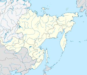
Map
Some of the largest Russian earthquakes since the latter half of the 20th century are the 1958/1963 and 2006/2007 earthquakes in the Kuril Islands near Japan, as well as the 1952/1959 earthquakes in the Kamchatka Peninsula, all of which were ≥ 8.0 M. See also the Kuril–Kamchatka Trench.
Earthquakes
| Date | Region | Mag. | MMI | Deaths | Injuries | Total damage / notes | |
|---|---|---|---|---|---|---|---|
| 2013-05-24 | Okhotsk Sea | 8.3 Mw | V | Significant in seismology | |||
| 2008-10-11 | North Caucasus | 5.8 Mw | VIII | 13 | 116 | ||
| 2008-08-27 | Lake Baikal | 6.3 Mw | VIII | Minor damage | [1] | ||
| 2007-08-02 | Tatar Strait | 6.2 Mw | VIII | 2 | 12 | Tsunami | [2] |
| 2007-01-13 | Kuril Islands | 8.1 Mw | VI | Tsunami | |||
| 2006-11-15 | Kuril Islands | 8.3 Mw | IV | 1 | Tsunami | ||
| 2006-04-21 | Kamchatka | 7.6 Mw | X | 40 | $55 million | ||
| 2003-09-27 | Altai Republic | 7.3 Mw | X | 3 | 5 | $10.6–33 million | |
| 1997-12-05 | Kamchatka | 7.7 Mw | VII | ||||
| 1995-05-27 | Sakhalin | 7.0 Ms | IX | 1989 | 750 | $64.1–300 million | |
| 1994-10-04 | Kuril Islands | 8.3 Mw | 12 | 1000+ | Tsunami | ||
| 1970-05-14 | North Caucasus | 6.7 Mw | VII | 101 | [3] | ||
| 1963-10-20 | Kuril Islands | 7.8 Mw | Tsunami | ||||
| 1963-10-13 | Kuril Islands | 8.5 Mw | IX | Tsunami | |||
| 1959-05-04 | Kamchatka | 8.0 Ms | VIII | 1 | 13 | Tsunami | |
| 1958-11-06 | Kuril Islands | 8.3 Mw | [4] | ||||
| 1952-11-05 | Kamchatka | 9.0 Mw | XI | 2,336 | |||
| 1923-04-13 | Kamchatka | 6.8 Mw | X | 18 | Tsunami | [5][6] | |
| 1923-02-03 | Kamchatka | 8.4 Ms | XI | 3 | |||
| 1918-09-07 | Kuril Islands | 8.1 Mw | 23 | 17 | Tsunami | [7] | |
| 1911-01-03 | Kazakhstan, Kyrgyzstan | 7.7 Mw | X | 452 | Severe damage | ||
| 1907-10-21 | Uzbekistan, Tajikistan | 7.4 Ms | IX | 12,000–15,000 | |||
| Note: The inclusion criteria for adding events are based on WikiProject Earthquakes' notability guideline that was developed for stand alone articles. The principles described also apply to lists. In summary, only damaging, injurious, or deadly events should be recorded. | |||||||
gollark: Banks primarily use complex COBOL-based mainframe programs, you see.
gollark: They can't.
gollark: ħħħħħħħ
gollark: Maybe the standard library.
gollark: None of those should be builtin, but in librarriieieieieies.
References
- USGS. "M 6.3 - Lake Baykal region, Russia". United States Geological Survey.
- USGS. "M 6.2 - Tatar Strait, Russia". United States Geological Survey.
- "M 6.7 - Caucasus region, Russia". United States Geological Survey. Retrieved July 3, 2019.
- "M 8.3 - Kuril Islands". United States Geological Survey. Retrieved March 12, 2018.
- "M 6.8 - near the east coast of the Kamchatka Peninsula, Russia". United States Geological Survey. Retrieved July 3, 2019.
- "Tsunami Event: KAMCHATKA". National Geophysical Data Center. Retrieved July 3, 2019.
- "M 8.1 - Kuril Islands". United States Geological Survey. Retrieved July 3, 2019.
This article is issued from Wikipedia. The text is licensed under Creative Commons - Attribution - Sharealike. Additional terms may apply for the media files.
