List of cities in Nebraska
Nebraska is a state located in the Midwestern United States.

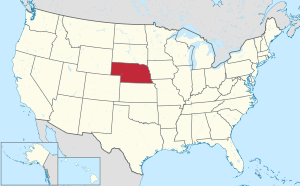
Map of the United States with Nebraska highlighted
Incorporated communities in Nebraska are legally classified as cities or villages, depending on their population.[1] This list includes only those classified as cities; for villages, see List of villages in Nebraska.
List of largest cities in Nebraska by population
Population data based on 2019 census. (top 57)[2]
| 2014 Rank | City | 2016 Estimate[3] | 2010 Census[4] | Change | County |
|---|---|---|---|---|---|
| 1 | Omaha | 446,970 | 408,958 | +9.29% | Douglas |
| 2 | Lincoln | 280,364 | 258,379 | +8.51% | Lancaster |
| 3 | Bellevue | 53,505 | 50,137 | +6.72% | Sarpy |
| 4 | Grand Island | 51,517 | 48,520 | +6.18% | Hall |
| 5 | Kearney | 33,520 | 30,787 | +8.88% | Buffalo |
| 6 | Fremont | 26,519 | 26,397 | +0.46% | Dodge |
| 7 | Hastings | 24,991 | 24,907 | +0.34% | Adams |
| 9 | North Platte | 24,110 | 24,733 | −2.52% | Lincoln |
| 8 | Norfolk | 24,348 | 24,210 | +0.57% | Madison |
| 10 | Columbus | 22,851 | 22,111 | +3.35% | Platte |
| 11 | Papillion | 19,597 | 18,894 | +3.72% | Sarpy |
| 12 | La Vista | 17,143 | 15,758 | +8.79% | Sarpy |
| 13 | Scottsbluff | 14,883 | 15,039 | −1.04% | Scotts Bluff |
| 14 | South Sioux City | 13,120 | 13,353 | −1.74% | Dakota |
| 15 | Beatrice | 12,362 | 12,459 | −0.78% | Gage |
| 16 | Lexington | 10,004 | 10,230 | −2.21% | Dawson |
| 17 | Alliance | 8,403 | 8,491 | −1.04% | Box Butte |
| 18 | Gering | 8,360 | 8,500 | −1.65% | Scotts Bluff |
| 19 | Blair | 8,089 | 7,990 | +1.24% | Washington |
| 20 | York | 7,860 | 7,766 | +1.21% | York |
| 21 | McCook | 7,526 | 7,698 | −2.23% | Red Willow |
| 22 | Nebraska City | 7,347 | 7,289 | +0.80% | Otoe |
| 23 | Ralston | 7,329 | 5,943 | +23.32% | Douglas |
| 25 | Crete | 7,059 | 6,960 | +1.42% | Saline |
| 24 | Seward | 7,219 | 6,964 | +3.66% | Seward |
| 26 | Sidney | 6,888 | 6,757 | +1.94% | Cheyenne |
| 27 | Plattsmouth | 6,479 | 6,502 | −0.35% | Cass |
| 28 | Schuyler | 6,106 | 6,211 | −1.69% | Colfax |
| 29 | Chadron | 5,725 | 5,851 | −2.15% | Dawes |
| 32 | Gretna | 5,060 | 4,441 | +13.94% | Sarpy |
| 30 | Wayne | 5,573 | 5,660 | −1.54% | Wayne |
| 31 | Holdrege | 5,555 | 5,495 | +1.09% | Phelps |
| 33 | Ogallala | 4,543 | 4,737 | −4.10% | Keith |
| 34 | Wahoo | 4,499 | 4,508 | −0.20% | Saunders |
| 35 | Aurora | 4,484 | 4,479 | +0.11% | Hamilton |
| 36 | Falls City | 4,214 | 4,325 | −2.57% | Richardson |
| 37 | Cozad | 3,805 | 3,977 | −4.32% | Dawson |
| 39 | Fairbury | 3,714 | 3,942 | −5.78% | Jefferson |
| 40 | O'Neill | 3,631 | 3,705 | −2.00% | Holt |
| 38 | Waverly | 3,786 | 3,277 | +15.53% | Lancaster |
| 42 | Gothenburg | 3,475 | 3,574 | −2.77% | Dawson |
| 41 | Broken Bow | 3,539 | 3,559 | −0.56% | Custer |
| 44 | Auburn | 3,299 | 3,460 | −4.65% | Nemaha |
| 43 | West Point | 3,327 | 3,364 | −1.10% | Cuming |
| 45 | Minden | 2,996 | 2,923 | +2.50% | Kearney |
| 46 | Central City | 2,905 | 2,934 | −0.99% | Merrick |
| 47 | David City | 2,815 | 2,906 | −3.13% | Butler |
| 48 | Valentine | 2,803 | 2,737 | +2.41% | Cherry |
| 49 | Ashland | 2,566 | 2,453 | +4.61% | Saunders |
| 50 | Kimball | 2,400 | 2,496 | −3.85% | Kimball |
| 51 | Madison | 2,364 | 2,438 | −3.04% | Madison |
| 52 | St. Paul | 2,349 | 2,290 | +2.58% | Howard |
| 53 | Milford | 2,194 | 2,090 | +4.98% | Seward |
| 55 | Geneva | 2,162 | 2,217 | −2.48% | Fillmore |
| 57 | Imperial | 2,047 | 2,071 | −1.16% | Chase |
| 56 | Ord | 2,078 | 2,112 | −1.61% | Valley |
| 54 | Valley | 2,172 | 1,875 | +15.84% | Douglas |
Alphabetical listing
C
H
J
S
U
gollark: <@212622994932105216> Pretty sure single/dual channel is an either/or thing. I don't know if each channel can support different amounts of DIMMs, so I wouldn't recommend that.
gollark: Indeed.
gollark: Shame you can't trade with groups of villagers automatically.
gollark: Bedrock Edition is much better performing but not very moddable, overmonetized, and lacking in features.
gollark: <@!235768051683950593> TomatOS is patched now I think.
See also
References
- "Nebraska Incorporated Places by Legal Classification". Nebraska Department of Economic Development. Retrieved June 14, 2016.
- "Nebraska State & County QuickFacts". U.S. Census Bureau. Archived from the original on October 14, 2012. Retrieved October 10, 2012.
- "Annual Estimates of the Resident Population for Incorporated Places: April 1, 2010 to July 1, 2013". United States Census Bureau. Archived from the original on 22 May 2015. Retrieved 16 July 2015.
- "2010 Census Redistricting Data (Public Law 94-171) Summary File". American FactFinder2. U.S. Census Bureau, 2010 Census. Retrieved 9 June 2015.
This article is issued from Wikipedia. The text is licensed under Creative Commons - Attribution - Sharealike. Additional terms may apply for the media files.
