List of bridges in Seattle
The city of Seattle, Washington, United States, has multiple bridges that are significant due to their function, historical status, or engineering. Bridges are needed to cross the city's waterways and hilly topography.[1] Twelve bridges have been granted historical status by the city, federal government, or both. Seattle also has some of the only permanent floating pontoon bridges in the world.[2]
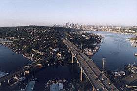
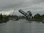
Original crossings over Seattle's mudflats were typically supported by timber piles. Lake Washington and Puget Sound are to the east and west of the city, respectively. They connect via a series of canals and Lake Union that are collectively known as the Lake Washington Ship Canal.[3] The four double-leaf bascule bridges crossing the Ship Canal are the oldest still used in the city, having opened between 1917 and 1930. The easternmost—the Montlake and University bridges—connect neighborhoods south of the canal to the University District. The Fremont Bridge crosses the center of the canal and is one of the most often raised drawbridges in the world due to its clearance over the water of only 30 feet (9.1 m).[4] The westernmost crossing of the ship canal is the Ballard Bridge.[5]
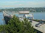
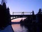
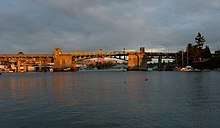
Floating bridges carry Interstate 90 and State Route 520 across Lake Washington to the Eastside suburbs.[6] The SR 520 Albert D. Rosellini Evergreen Point Floating Bridge, which opened in 2016 as the replacement for another floating bridge at the same site,[7][8] is the longest floating bridge in the world.[9][10] The Lacey V. Murrow Memorial Bridge had previously been replaced after the original span sunk in 1990 when water filled an open maintenance hatch during refurbishing. Age and the 2001 Nisqually earthquake have damaged several other spans. The risk of future earthquakes has increased the need to replace already deteriorated bridges in the city, such as the Alaskan Way Viaduct (removal began in January 2019) and the Magnolia Bridge.[11][12]
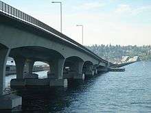
West Seattle is on a peninsula separated from downtown by the Duwamish River. The West Seattle Bridge is the primary roadway crossing the river.[13] The neighborhood's Spokane Street Bridge is the world's first and only hydraulically operated concrete double-leaf swing bridge.[14]
List of bridges
| Key: Year opened |
|---|
| *: Listed in the National Register of Historic Places[15] |
| †: Listed as a city landmark[16] |


.jpg)
_from_east_end_after_opening%2C_April_2016.jpg)

Demolished or defunct bridges
| Name (Alternative names in parenthesis) |
Image | Year opened | Year closed | Type | Length | Spanned | Carried | Replacement | Coordinates |
|---|---|---|---|---|---|---|---|---|---|
| Alaskan Way Viaduct | 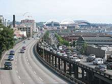 | 1953[41] | 2019[41] | Viaduct | 11,088 ft (3,380 m)[42] | Alaskan Way | State Route 99 | SR 99 Tunnel[41] | 47.6040°N 122.3382°W |
| Fairview Avenue North Bridge | 1948 (west) 1963 (east)[43] | 2019[44] | Timber-pile bridge[45] | mudflats in Lake Union[44] | Fairview Avenue N[45] | Fairview Avenue N[45] | 47.6312°N 122.3278°W | ||
| Fremont Bridge (c. 1891) | 1890[46] | 1911[47] | Trestle[46] | Fremont Cut[46] | Road connecting Fremont Avenue N and 4th Avenue N | Fremont Bridge (1911)[46] | 47.6475°N 122.3497°W | ||
| Fremont Bridge (1911) | 1911[46] | 1914[47] | Trestle | Fremont Cut[46] | Road connecting Fremont Avenue N and 4th Avenue N | Fremont Bridge[46] | 47.6475°N 122.3497°W | ||
| Governor Albert D. Rosellini Bridge—Evergreen Point (Evergreen Point Floating Bridge, 520 Bridge) | 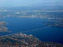 | 1963[22] | 2016[48] | Floating pontoon | 7,578 ft (2,310 m)[22] | Lake Washington | State Route 520 | Evergreen Point Floating Bridge (2016)[48] | 47.6405°N 122.2609°W |
| Grant Street Bridge | 1886[49] | c. 1910 | Timber-pile bridge | 2,640 ft (805 m) or 5,280 ft (1,609 m)[50][51] | Duwamish River and Elliott Bay mudflats[52] | Primary thoroughfare from Jackson Street to South Seattle[49] | Seattle Boulevard (later Airport Way)[49] | ||
| Grant Street Electric Railway Bridge | .jpeg) | before 1891 | ? | Wooden truss bridge | Duwamish River | Grant Street Electric Railway | South Park Bridge | 47.3146°N 122.1851°W | |
| Latona Street Bridge | 1891[lower-alpha 5] | 1919 | Primarily cantilevered timber[53] | 100 ft (30 m)[53] | Narrow point of north west Lake Union[53] | Seattle Electric Company (original) General traffic (after completion of second span)[53] | University Bridge[53] | 47.6525°N 122.3421°W | |
| Post Avenue Bridge[54] | 1890[55] | 2017[lower-alpha 6] | Timber-pile bridge[55] | 240 ft (73 m)[54] | Elliott Bay waterfront[55] | Post Avenue | Post Avenue | 47.6032°N 122.3362°W | |
| Stone Way Bridge | _(cropped).jpeg) | 1911 | 1918 | Trestle | 2,700 ft (823 m) | Lake Union | Stone Way | Fremont Bridge | 47.6463°N 122.3437°W |
| West Wheeler Street Bridge | .gif) | before 1914 | 1924 | Trestle | mudflats in Interbay | West Wheeler Street, and a second street on a diagonal | Magnolia Bridge | 47.6408°N 122.3813°W | |
| West Seattle Bridge[56] c. 1900 | c. 1900 | c. 1911 | "swinging gate" | Duwamish River | (unnamed, future route of Spokane Street); water main | West Seattle Bridge c. 1911 | |||
| West Seattle Bridge[56] c. 1911 (Spokane Street Bridge)[57][58] | .jpeg) | c. 1911[57] | c. 1918[58] | Swing bridge | Duwamish West Waterway | Spokane Street; water main | West Seattle Bridge c. 1918 | ||
| West Seattle Bridge c. 1918[56] (Spokane Street Bridge)[58] | .jpeg) | c. 1918[58] | 1924 | Swing bridge | Duwamish West Waterway | Spokane Street | West Seattle Bridge (1924) | ||
| West Seattle Bridge (1924) (Bridge No. 1; North Bridge) [56] | .jpg) | 1924 | 1978 | Bascule | Duwamish West Waterway | Spokane Street | West Seattle Bridge (1984) and Spokane Street Bridge |
See also


| Wikimedia Commons has media related to Bridges in Seattle. |
- List of bridges on the National Register of Historic Places in Washington (state)
- List of Seattle landmarks
- South Park Bridge, just outside the city limits
- East Channel Bridge, connects the Interstate 90 bridges with the Eastside suburbs via Mercer Island
- Tacoma Narrows Bridge, a pair of suspension bridges in nearby Tacoma
- Wilburton Trestle, a historic wooden railway trestle in nearby Bellevue
Notes
- A parallel span was built in 1996; the approaches to the original span were partially demolished and the structure was retrofitted between 1996 and 1998.[21]
- The city rebuilt the approaches at each end of the bridge between 2006 and 2007.[24]
- All but the approaches replace the original bridge, which opened in 1940 and sank in 1990.[22]
- Remodeled and dedicated in 1933.[19]
- Carried the first streetcar line across Lake Union, but converted to pedestrian, horse, and vehicle traffic when a parallel span was built for streetcars in 1901.[53]
- Paved with creosoted wood blocks in 1911 before being completely asphalted over in 1945.[55]
References
- Petroski, Henry (2003). "Floating Bridges" (PDF). American Scientific. 91: 302–306.
- Gutierres, Scott (February 29, 2012). "Washington: Floating Bridge Capitol of the World". Seattle Post Intelligencer. Retrieved January 4, 2015.
- Insiders' Guide to Seattle. Insiders Guides. 2010. p. 17. ISBN 978-0-7627-5544-8.
- Posada, Janice (August 21, 1995). "The People Who Operate Seattle's Movable Bridges Can Attest to the Ups and Downs of Solitary Work Tender Times". Seattle Post-Intelligencer.
- Ohlsen, Becky (2008). Seattle. Lonely Planet. p. 44. ISBN 978-1-74059-834-7.
- Petroski, Henry (2005). Pushing the Limits: New Adventures in Engineering. Knopf. p. 40. ISBN 978-1-4000-4051-3.
- Lindblom, Mike (January 12, 2016). "New 520 bridge to open in April; walkers, bicyclists get to try it first". The Seattle Times. Retrieved April 17, 2016.
- "Traffic switch from old SR 520 floating bridge to new bridge" (PDF). Washington State Department of Transportation. January 2016. Archived from the original (PDF) on April 17, 2016. Retrieved April 20, 2016.
- Gaudette, Karen (April 26, 2005). "DOT on 520 project: "The Sooner the Better"". The Seattle Times. Retrieved February 22, 2011.
- "Longest bridge, floating bridge". Guinness World Records. Retrieved April 17, 2016.
- "Demolition of the Alaskan Way Viaduct begins". Seattle Post-Intelligencer. February 18, 2011. Retrieved February 27, 2011.
- Cunningham, Jeffrey (November 25, 2014). "Magnolia's Bridges". Queen Anne & Magnolia News. Retrieved December 19, 2014.
- Southwest Seattle Historical Society, Log House Museum (2010). Images of America West Seattle. Arcadia Publishing. p. 20. ISBN 978-0-7385-8133-0.
- Holstine, Craig; Hobbs, Richard (2005). Spanning Washington: Historic Highway Bridges of the Evergreen State. Washington State University Press. ISBN 978-0-87422-281-4.
- National Register of Historic Places; Annual Listing of Historic Properties (Part II) (PDF). National Park Service. March 1, 1983. p. 8669.
- "Landmarks and Designation". City of Seattle Department of Neighborhoods. Retrieved February 28, 2011.
- Landmark Preservation Board (April 1, 1975). "Seattle Historic Building Data Sheet" (PDF). City of Seattle. Archived from the original (PDF) on December 20, 2013. Retrieved December 19, 2014.
- Dorpat, Paul (August 12, 2001). "A Bridge Loses Track". The Seattle Times. Archived from the original on February 17, 2009. Retrieved February 3, 2011.
- "Bridges and Roadway Structures". City of Seattle Department of Transportation. Retrieved February 3, 2011.
- Blecha, Peter (January 23, 2011). "Ravenna Park (Seattle)". HistoryLink.org Online Encyclopedia of Washington State History. Retrieved November 28, 2011.
- "1st Avenue S. Bridge". Washington State Department of Transportation. Retrieved February 3, 2011.
- The World Almanac and Book of Facts 2008. World Almanac Books. 2008. pp. 737–739. ISBN 978-1-60057-072-8.
- "Sound Log Towers Expect Increase in Business". Seattle Daily Times. February 5, 1918. p. 40.
- Gilore, Susan (May 22, 2006). "Project Will Keep Bus Traffic off Bridge in Fremont". The Seattle Times. Retrieved February 22, 2011.
- Shellin Atly, Elizabeth (January 2, 1980). "Nomination Form" (PDF). City of Seattle; Department of Community Development/Office of Urban Conservation. Archived from the original (PDF) on March 24, 2014. Retrieved December 19, 2014.
- Gilore, Susan (July 15, 2008). "3 Designs Released for Fence on Aurora Bridge". The Seattle Times. Retrieved February 22, 2010.
- "West Seattle Bridge Honors Jeanette Williams". West Seattle Herald. October 30, 2009.
- "The Northwest Today". The Register-Guard. July 8, 1984. p. 5A.
- Long, Priscilla (December 23, 2007). "Seattle's 12th Avenue South (Dearborn Street) Bridge Is Built in 1911". HistoryLink.org Online Encyclopedia of Washington State History.
- "View From on High". City of Seattle Department of Transportation. August 24, 2010. Retrieved February 27, 2011.
- "Magnolia Bridge Site Recommended". The Daily Journal of Commerce. February 9, 2006. Archived from the original on March 30, 2006. Retrieved December 19, 2014.
- Gelula, Melisse (2002). Fodor's Cityguide Seattle. Fodor's Travel Publications. p. 171. ISBN 978-0-676-90194-8.
- Wilma, David (April 17, 2001). "Seattle Landmarks: Queen Anne Drive Bridge (1936)". HistoryLink.org Online Encyclopedia of Washington State History. Retrieved December 19, 2014.
- Shellin Atly, Elizabeth (January 2, 1980). "Nomination Form" (PDF). City of Seattle; Department if Community Development/Office of Urban Conservation. Archived from the original (PDF) on March 24, 2014. Retrieved December 19, 2014.
- The Encyclopedia Americana: A Library of Universal Knowledge, Volume 4. Encyclopedia Americana Corporation. 1918. p. 504. ISBN 978-1-2763-9784-1.
- "Final List of Nationally and Exceptionally Significant Features of the Federal Interstate Highway System". Federal Highway Administration, USDOT. Retrieved December 19, 2014.
- Dorpat, Paul; McCoy, Genevieve (1998). Building Washington: A History of Washington State Public Works. Tartu Publications. p. 131. ISBN 978-0-9614357-9-0.
- Long, Priscilla (December 23, 2007). "Schmitz Park Bridge in West Seattle Is Completed in December 1936". HistoryLink.org Online Encyclopedia of Washington State History. Retrieved December 19, 2014.
- "Weekly Roundup of Facts, Figures and Forecasts". The Seattle Times. August 25, 2004. Retrieved July 11, 2011.
- Long, Priscilla (January 23, 2008). "Seattle's Ravenna Park Bridge Is Constructed in 1913". HistoryLink.org Online Encyclopedia of Washington State History. Retrieved November 28, 2011.
- Baumann, Lisa (January 9, 2019). "Closure of Seattle's Alaskan Way Viaduct will stall traffic for weeks". USA Today. Associated Press. Retrieved January 12, 2019.
- Beason, Tyrone (November 25, 2015). [/https://www.seattletimes.com/pacific-nw-magazine/seattles-gritty-bridges-are-built-for-function-not-beauty "Seattle's gritty bridges are built for function, not beauty"] Check
|url=value (help). Seattle Times. Retrieved May 13, 2020. - Lindblom, Mike (September 5, 2016). "Shut Fairview, replace 2 bridges all at once? Plan draws fire". The Seattle Times. Retrieved September 21, 2019.
- Lindblom, Mike (September 20, 2019). "Traffic jam ahead: Seattle's Fairview Avenue bridge closes Monday for an 18-month rebuild". The Seattle Times. Retrieved September 20, 2019.
- Whright, Molly (September 16, 2019). "HA critical safety project to replace the aging Fairview Ave N bridge kicks off construction next week". Seattle Department of Transportation. Retrieved September 21, 2019.
- Long, Priscilla (May 25, 2001). "HistoryLink Essay 3309, Wood trestle spans canal and connects Seattle's Fremont neighborhood with the foot of Queen Anne Hill in 1892". HistoryLink. Retrieved September 21, 2019.
- Dorpat, Paul (June 7, 2014). "Seattle Now & Then: The Lake Union Dam Washout". pauldorpat.com. Retrieved December 21, 2018.
- Peer, Steve (June 16, 2016). "We're saying goodbye to the old SR 520 bridge – one piece at a time". WSDOT Blog. Washington State Department of Transportation. Retrieved January 12, 2019.
- Tobin, Caroline (May 2004). "Beacon Hill Historic Context Statement" (PDF). City Of Seattle Department Of Neighborhoods. Retrieved September 21, 2019.
- Pacific Reporter, Vol 29. West Publishing Company. 1892. p. 1059.
- Bagely, Clarence (1916). History of Seattle from the Earliest Settlement to the Present Time, Volume 2. Seattle, WA: S.J. Clarke Publishing Company. p. 821.
- Stein, Alan J. (January 18, 2000). "HistoryLink essay 2074, Thomson, Reginald Heber (1856-1949)". HistoryLink. Retrieved September 21, 2019.
- Calbick, John (June 28, 2017). "Latona Bridge and University Bridge (Seattle)". HistoryLink. Retrieved September 20, 2019.
- "Post Avenue Bridge Replacement Project". Seattle Department of Transportation. Retrieved September 20, 2019.
- Silver, John (December 28, 2017). "Crews Remove What's Left Of An 1890 Wooden Bridge Under Post Avenue". Seattle Daily Journal of Commerce. Retrieved September 20, 2019.
- Paul Dorpat (1984). "100 - Six Bridges to West Seattle". Seattle Now and Then. Tartu.
- "Contract Awarded for Spokane Street Bridge". Seattle Daily Times. November 23, 1910. p. 6.
- "Would Cancel License of Employment Agency". Seattle Daily Times. June 25, 1918. p. 15.
[A city council bill] authorizes the Board of Public Works to remove the old Spokane Street Bridge and appropriates $1500 for the work.