List of airports in Togo
This is a list of airports in Togo, sorted by location.
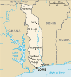
Map of Togo
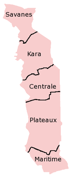
Togo's five regions
Togo, officially the Togolese Republic, is a country in West Africa bordered by Ghana to the west, Benin to the east, Burkina Faso to the north, and the Gulf of Guinea to the south. The capital city is Lomé. The country is divided into five regions.
Airports
Airport names shown in bold indicate the airport has scheduled service on commercial airlines.
| City served | Region | ICAO | IATA | Airport name |
|---|---|---|---|---|
| Anié | Plateaux | DXKP | Kolokope Airport | |
| Atakpamé | Plateaux | DXAK | Akpaka Airport | |
| Dapaong | Savanes | DXDP | Djangou Airport | |
| Lomé | Maritime | DXXX | LFW | Lomé-Tokoin Airport (Gnassingbé Eyadéma Int'l) |
| Niamtougou | Kara | DXNG | LRL | Niamtougou International Airport |
| Sansanné-Mango | Savanes | DXMG | Sansanné-Mango Airport | |
| Sokodé | Centrale | DXSK | Sokodé Airport |
gollark: Actually, do you mean you're buying a prebuilt computer or buying parts and assembling them>
gollark: You mean a computer build? Okay, I can look over it for obvious issues.
gollark: 𝒂𝒍𝒍 𝒈𝒍𝒐𝒓𝒚 𝒕𝒐 𝒕𝒉𝒆 𝒖𝒏𝒊𝒄𝒐𝒅𝒆 𝒄𝒐𝒏𝒔𝒐𝒓𝒕𝒊𝒖𝒎
gollark: If you can magically get the hydrogen separately that would be useful too.
gollark: Oh right. You said carbon earlier, is all.
References
- "ICAO Location Indicators by State" (PDF). International Civil Aviation Organization. 12 January 2006. Archived from the original (PDF) on 5 September 2012.
- "UN Location Codes: Togo". UN/LOCODE Code List 2011-2. UNECE. February 2012. - includes IATA codes
- Great Circle Mapper: Airports in Togo - IATA and ICAO codes
- World Aero Data: Airports in Togo - ICAO codes
This article is issued from Wikipedia. The text is licensed under Creative Commons - Attribution - Sharealike. Additional terms may apply for the media files.