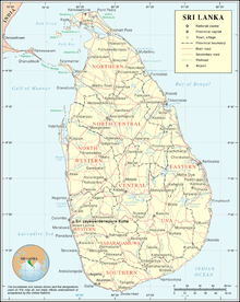
List of airports in Sri Lanka
Airports
Airport names shown in bold indicate the facility has scheduled passenger service on a commercial airline.
International airports
| Location served | Province | ICAO | IATA | Airport name | Usage | Runway(s) | Coordinates |
|---|---|---|---|---|---|---|---|
| Batticaloa | Eastern | VCCB | BTC | Batticaloa International Airport | Public/Military | 1,560 m (5,120 ft) | 07°42′18″N 81°40′38″E |
| Colombo | Western | VCBI | CMB | Bandaranaike International Airport | Public/Military | 3,350 m (10,990 ft) 4,000 m (13,000 ft) | 07°10′52″N 79°53′06″E |
| Colombo | Western | VCCC | RML | Ratmalana International Airport | Public/Military | 1,830 m (6,000 ft) | 06°49′23″N 79°53′12″E |
| Hambantota | Southern | VCRI | HRI | Mattala Rajapaksa International Airport | Public | 3,500 m (11,500 ft) | 06°17′10″N 81°07′32″E |
| Jaffna | Northern | VCCJ | JAF | Jaffna International Airport | Public/Military | 2,375 m (7,792 ft) | 09°47′32″N 80°04′12″E |
Domestic airports
Waterdromes
| Location served | Province | ICAO | IATA | Airport name | Usage | Runway(s) | Coordinates |
|---|---|---|---|---|---|---|---|
| Ampara | Eastern | AFK | Kondavattavan Tank Waterdrome | ||||
| Arugam Bay | Eastern | AYY | Arugam Bay Lagoon Waterdrome | ||||
| Batticaloa | Eastern | Lady Manning Drive Waterdrome | |||||
| Bentota | Southern | BJT | Bentota River Airport | ||||
| Castlereigh | Central | NUF | Castlereigh Reservoir Waterdrome | ||||
| Colombo-Dandugama | Western | DGM | Dandugama Water Aerodrome | ||||
| Colombo-Peliyagoda | Western | KEZ | Kelani River-Peliyagoda Waterdrome | ||||
| Dambulla | Central | DBU | Ibbankatuwa Tank Waterdrome (Dambulu Oya Tank) | ||||
| Dikwella | Southern | DIW | Mawella Lagoon Airport | ||||
| Hambantota | Southern | HBT | Bandagiriya Tank Waterdrome | ||||
| Iranamadu | Northern | IRU | Iranamadu Waterdrome | ||||
| Jaffna | Northern | Jaffna Waterdrome | |||||
| Kalpitiya | North Western | Kalpitiya Waterdrome | |||||
| Kandy-Polgolla | Central | KDZ | Polgolla Reservoir Waterdrome | ||||
| Kandy-Victoria | Central | KDW | Victoria Dam Waterdrome | ||||
| Koggala | Southern | KCT | Koggala Lagoon Waterdrome | ||||
| Nuwara Eliya | Central | NUA | Lake Gregory Waterdrome | ||||
| Pasikudah | Eastern | PQD | Passikudah Waterdrome | ||||
| Tissamaharama | Southern | TTW | Tissa Tank Waterdrome | ||||
| Trincomalee | Eastern | THW | Trincomalee Harbour Waterdrome |
gollark: And the abstractions aren't actually that bad either.
gollark: Minoteaur is HIGHLY optimized and ships a mere 40KB of JS.
gollark: I mean, the OS imposes basically no overhead on pure computing tasks, good JS JITs can get you up to 50% of native speed on some things, browsers have ridiculously advanced things going on to optimize rendering, etc.
gollark: Java isn't actually that slow.
gollark: Those don't particularly exist, though.
See also
- List of Sri Lankan air force bases
- List of airports by ICAO code: V § VC – Sri Lanka
- Wikipedia:WikiProject Aviation/Airline destination lists: Asia#Sri Lanka
References
- "Aeronautical Information Publication". Aeronautical Information Services of Sri Lanka. Archived from the original on 2016-01-24. Retrieved 2016-01-24.
- "Aerodrome Index Chart" (PDF). Aeronautical Information Services of Sri Lanka. Archived from the original (PDF) on 2016-01-24. Retrieved 2016-01-24.
- "Location Indicators by State" (PDF). International Civil Aviation Organization. 17 September 2010. p. 100.
- "Airline and Airport Code Search". International Air Transport Association.
- "Code for Trade and Transport Locations (UN/LOCODE)". United Nations Economic Commission for Europe.
- "Search for Locations – country:LK". Great Circle Mapper.
- "Airports in Sri Lanka". World Aero Data.
- "Airports in Sri Lanka". Airport & Aviation Services (Sri Lanka) Limited.
This article is issued from Wikipedia. The text is licensed under Creative Commons - Attribution - Sharealike. Additional terms may apply for the media files.


