Lipinki, Lesser Poland Voivodeship
Lipinki [lʲiˈpʲiŋkʲi] is a village in Gorlice County, Lesser Poland Voivodeship, in southern Poland. It is the seat of the gmina (administrative district) called Gmina Lipinki. It lies approximately 11 kilometres (7 mi) east of Gorlice and 107 km (66 mi) south-east of the regional capital Kraków.[1]
Lipinki | |
|---|---|
Village | |
Oil rig "Dziadek" in Lipinki | |
 Lipinki | |
| Coordinates: 49°40′45″N 21°18′0″E | |
| Country | |
| Voivodeship | Lesser Poland |
| County | Gorlice |
| Gmina | Lipinki |
| Population | 2,400 |
| Website | http://www.e-lipinki.pl |
The village has a population of 2,400.
History
As a result of the first of Partitions of Poland (Treaty of St-Petersburg dated 5 July 1772, the Galicia area was attributed to the Habsburg Monarchy.[2] For more details, see the article Kingdom of Galicia and Lodomeria.
A postoffice was opened in 1890, under the Bezirkshauptmannschaft Gorlice.[3]

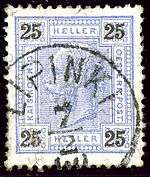
Austrian KK 25 heller stamp, cancelled LIPINKI in 1900
gollark: <@!747067747569106974> <@!747067747569106974> <@!747067747569106974> <@!747067747569106974> <@!747067747569106974> <@!747067747569106974> <@!747067747569106974> <@!747067747569106974> <@!747067747569106974> <@!747067747569106974> <@!747067747569106974> <@!747067747569106974> <@!747067747569106974> <@!747067747569106974> <@!747067747569106974> <@!747067747569106974> <@!747067747569106974> <@!747067747569106974> <@!747067747569106974> <@!747067747569106974> <@!747067747569106974> <@!747067747569106974> <@!747067747569106974> <@!747067747569106974> <@!747067747569106974> <@!747067747569106974> <@!747067747569106974> <@!747067747569106974> <@!747067747569106974> <@!747067747569106974> <@!747067747569106974> <@!747067747569106974> <@!747067747569106974> <@!747067747569106974> <@!747067747569106974> <@!747067747569106974> <@!747067747569106974> <@!747067747569106974> <@!747067747569106974> <@!747067747569106974> <@!747067747569106974> <@!747067747569106974> <@!747067747569106974> <@!747067747569106974> <@!747067747569106974> <@!747067747569106974> <@!747067747569106974> <@!747067747569106974> <@!747067747569106974> <@!747067747569106974> <@!747067747569106974> <@!747067747569106974> <@!747067747569106974> <@!747067747569106974> <@!747067747569106974> <@!747067747569106974> <@!747067747569106974> <@!747067747569106974> <@!747067747569106974> <@!747067747569106974> <@!747067747569106974> <@!747067747569106974> <@!747067747569106974> <@!747067747569106974>
gollark: https://discordapp.com/oauth2/authorize?&client_id=509849474647064576&scope=bot&permissions=68608
gollark: Thus, IMMEDIATELY ADÐ? Also adδ my bot IMMEDIATELY utterly.
gollark: It apparently supports HTTP URLs.
gollark: https://top.gg/bot/736888501026422855
References
- "Central Statistical Office (GUS) - TERYT (National Register of Territorial Land Apportionment Journal)" (in Polish). 2008-06-01.
- Atlas des peuples d'Europe centrale, André et Jean Sellier, 1991, p.88
- Die postalischen Abstempelungen auf den österreichischen Postwertzeichen-Ausgaben 1867, 1883 und 1890, Wilhelm KLEIN, 1967
This article is issued from Wikipedia. The text is licensed under Creative Commons - Attribution - Sharealike. Additional terms may apply for the media files.
