Lindesnes Region
The Lindesnes Region (or Mandal Region) is the metropolitan region surrounding the town of Mandal in Southern Norway. The region has no governmental functions, but it encompasses five municipalities in Vest-Agder county, primarily covering two large river valleys: Mandalen and Audnedalen. The region is Norway's southernmost region and it borders the Kristiansand Region to the east and the Lister Region to the west.
Lindesnes Region Lindesnesregionen | |
|---|---|
Metropolitan Region (Metro) | |
 Lindesnes Lighthouse, the southernmost point of Norway | |
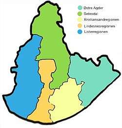 Lindesnes Region in orange, in the map of Agder. | |
| Coordinates: 58.6°N 7.8°E | |
| Country | Norway |
| Capital | Mandal |
| County (fylke) | Vest-Agder |
| Area | |
| • Total | 2,072.55 km2 (800.22 sq mi) |
| Population (2016) | |
| • Total | 25,454 |
| • Density | 12/km2 (32/sq mi) |
Municipalities
The Lindesnes Region includes the following municipalities:
| Nr | Map | Name | Coat of arms | Adm. center | Population[1] | Areal km²[2] |
Language | Location |
|---|---|---|---|---|---|---|---|---|
| 1002 | Mandal | Mandal | 15,529 | 222.56 | Bokmål | Coast | ||
| 1021 | Marnardal | Heddeland | 2,290 | 395.01 | Nøytral | Inland | ||
| 1026 | Åseral | Kyrkjebygda | 942 | 887.52 | Nynorsk | Inland | ||
| 1027 | Audnedal | Konsmo | 1,750 | 251.45 | Nøytral | Inland | ||
| 1029 | Lindesnes | Vigeland | 4,943 | 316.01 | Bokmål | Coast |
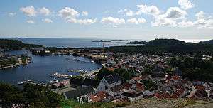
Mandal, the largest city and capital of the Lindesnes Region
gollark: No, I mean in terms of doing a similar thing without centralization. The "web of trust" model is probably not something most users would enjoy using.
gollark: DNS seems not great because of the whole centralization thing, but I'm not sure if there's a way around that.
gollark: Conversations HAVE been known to change in scope somewhat.
gollark: I have this freenom .tk one which brings many technical challenges.
gollark: I'm probably maybe* going to run a homeserver once I actually get a non-awful domain name.
References
- "Population 1 January. The whole country, counties and municipalities". Statistisk Sentralbyrå. Retrieved 2016-12-30.
- "Arealstatistikk for Norge" (PDF) (in Norwegian). Statens kartverk. 2014. Archived from the original (PDF) on 2014-04-09. Retrieved 2016-12-30.
| County |
|  |
|---|---|---|
| Cities |
| |
| Towns | ||
| Municipalities | ||
| Regions |
| |
This article is issued from Wikipedia. The text is licensed under Creative Commons - Attribution - Sharealike. Additional terms may apply for the media files.