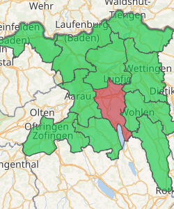
Lenzburg District
Lenzburg District is a district of the Canton of Aargau in Switzerland, lying at the center of the canton. The district capital is the town of Lenzburg. It has a population of 63,028 (as of 31 December 2018).[1]
Lenzburg District Bezirk Lenzburg | |
|---|---|
District | |
 Coat of arms | |
| |
| Country | |
| Canton | |
| Capital | Lenzburg |
| Area | |
| • Total | 102.71 km2 (39.66 sq mi) |
| Population (2018) | |
| • Total | 63,028 |
| • Density | 610/km2 (1,600/sq mi) |
| Time zone | UTC+1 (CET) |
| • Summer (DST) | UTC+2 (CEST) |
| Municipalities | 20 |
Geography
The Lenzburg district has an area, as of 2009, of 102.71 square kilometers (39.66 sq mi). Of this area, 42.6 km2 (16.4 sq mi) or 41.5% is used for agricultural purposes, while 34.14 km2 (13.18 sq mi) or 33.2% is forested. Of the rest of the land, 20.16 km2 (7.78 sq mi) or 19.6% is settled (buildings or roads).[2]
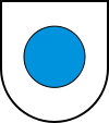
Coat of arms
The blazon of the district coat of arms is Argent a Hurt.[3]
Demographics
Bezirk Lenzburg has a population (as of December 2018) of 63,028.[1] As of June 2009, 19.7% of the population are foreign nationals.[4]
Economy
In 2000 there were 24,407 workers who lived in the district. Of these, 18,072 or about 74.0% of the residents worked outside the Lenzburg district while 14,959 people commuted into the district for work. There were a total of 21,294 jobs (of at least 6 hours per week) in the district.[5]
Religion
From the 2000 census, 12,952 or 27.9% were Roman Catholic, while 23,937 or 51.6% belonged to the Swiss Reformed Church. Of the rest of the population, there were 45 individuals (or about 0.10% of the population) who belonged to the Christian Catholic faith.[2]
Education
Of the school age population (in the 2008/2009 school year), there are 3,695 students attending primary school, there are 1,569 students attending secondary school, there are 971 students attending tertiary or university level schooling, and there are 12 students who are seeking a job after school in the municipality.[2]
Municipalities
The district contains a total of 20 municipalities:
| Coat of arms | Municipality | Population (31 December 2018)[1] |
Area, km2 |
|---|---|---|---|
| Ammerswil | 700 | 3.19 | |
| Boniswil | 1,428 | 2.78 | |
| Brunegg | 847 | 1.56 | |
| Dintikon | 2,229 | 3.73 | |
| Egliswil | 1,456 | 6.29 | |
| Fahrwangen | 2,137 | 5.00 | |
| Hallwil | 875 | 2.18 | |
| Hendschiken | 1,269 | 3.52 | |
| Holderbank | 1,320 | 2.32 | |
| Hunzenschwil | 4,016 | 3.27 | |
| Lenzburg | 10,574 | 11.33 | |
| Meisterschwanden | 2,960 | 6.86 | |
| Möriken-Wildegg | 4,439 | 6.62 | |
| Niederlenz | 4,776 | 326 | |
| Othmarsingen | 2,896 | 4.71 | |
| Rupperswil | 5,489 | 6.22 | |
| Schafisheim | 2,997 | 6.33 | |
| Seengen | 3,996 | 10.35 | |
| Seon | 5,288 | 9.61 | |
| Staufen | 3,336 | 3.58 | |
| Total | 63,028 | 102.75 |
References
- Swiss Federal Statistical Office - STAT-TAB, online database – Ständige und nichtständige Wohnbevölkerung nach institutionellen Gliederungen, Geburtsort und Staatsangehörigkeit (in German) accessed 23 September 2019
- Statistical Department of Canton Aargau - Aargauer Zahlen 2009 (in German) accessed 20 January 2010
- Flags of the World.com accessed 18-May-2010
- Statistical Department of Canton Aargau -Bereich 01 -Bevölkerung (in German) accessed 20 January 2010
- Statistical Department of Canton Aargau-Bereich 11 Verkehr und Nachrichtenwesen (in German) accessed 21 January 2010