Ledisol
Ledisol is a census town in the Khatra CD block in the Khatra subdivision of the Bankura district in the state of West Bengal, India.
Ledisol | |
|---|---|
Census Town | |
 Ledisol Location in West Bengal, India  Ledisol Ledisol (India) | |
| Coordinates: 22.9816°N 86.8634°E | |
| Country | |
| State | West Bengal |
| District | Bankura |
| Area | |
| • Total | 1.405 km2 (0.542 sq mi) |
| Population (2011) | |
| • Total | 5,056 |
| • Density | 3,600/km2 (9,300/sq mi) |
| Languages* | |
| • Official | Bengali, Santali, English |
| Time zone | UTC+5:30 (IST) |
| PIN | 722140 |
| Telephone/STD code | 03243 |
| Lok Sabha constituency | Bankura |
| Vidhan Sabha constituency | Ranibandh |
| Website | bankura |
Geography
 |
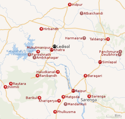
| Places in Khatra subdivision in Bankura district CT: census town, R: rural/ urban centre, C: craft centre, T: ancient/ temple centre Owing to space constraints in the small map, the actual locations in a larger map may vary slightly |
Location
Ledisol is located at 22.9816°N 86.8634°E.
Area overview
The map alongside shows the Khatra subdivision of Bankura district. Physiographically, this area is having uneven lands with hard rocks. In the Khatra CD block area there are some low hills. The Kangsabati project reservoir is prominently visible in the map. The subdued patches in the map show forested areas[1]It is an almost fully rural area.[2]
Note: The map alongside presents some of the notable locations in the subdivision. All places marked in the map are linked in the larger full screen map.
Demographics
According to the 2011 Census of India, Ledisol had a total population of 5,056, of which 2,582 (51%) were males and 2,474 (49%) were females. There were 447 persons in the age range of 0–6 years. The total number of literate persons in Ledisol was 4,235 (91.89% of the population over 6 years).[3]
.*For language details see Khatra (community development block)#Language and religion
Infrastructure
According to the District Census Handbook 2011, Bankura, Ledisol covered an area of 1.405 km2. Among the civic amenities, it had 13.5 km of roads, the protected water supply involved tap water from treated sources, tubewell/ borewell. It had 670 domestic electric connections, 272 road lighting points. Among the medical facilities it had 1 dispensary/ health centre, 1 family welfare centre, 1 maternity and child welfare centre, 4 medicine shops. Among the educational facilities it had were 2 primary schools, 1 middle school, 1 secondary school, 1 senior secondary school, the nearest general degree college at Supur 4 km away. It had 2 non-formal education centres (Sarva Shiksha Abhiyan). Among the social cultural and recreational facilities, it had 1 cinema theatre, 1 auditorium/ community hall, 1 public library, 1 reading room. The three most important commodities it manufactured were rice, wheat, mustard oil. It had the branch of 1 cooperative bank.[4]
References
- "District Census Handbook Bankura" (PDF). pages 13-17. Directorate of Census Operations West Bengal. Retrieved 23 April 2020.
- "District Statistical Handbook 2014 Bankura". Table 2.4b. Department of Statistics and Programme Implementation, Government of West Bengal. Retrieved 23 April 2020.
- "CD block Wise Primary Census Abstract Data(PCA)". West Bengal – District-wise CD Blocks. Registrar General and Census Commissioner, India. Retrieved 14 April 2020.
- "District Census Handbook Bankura, Census of India 2011, Series 20, Part XII A" (PDF). Section II Town Directory, Pages 1429-1434; Statement I: Status and Growth History, Page 1429; Statement II: Physical Aspects and Location of Towns, Page 1430; Statement III: Civic and other Amenities, Page 1431; Statement IV: Medical Facilities 2009, Page 1432; Statement V: Educational, Recreational and Cultural Facilities, Page 1432; Statement VI:Industry and Banking. Directorate of census Operations V, West Bengal. Retrieved 7 April 2020.