Balsi Purbapara
Balsi Purbapara is a village in the Patrasayer CD block in the Bishnupur subdivision of the Bankura district in the state of West Bengal, India.
Balsi Purbapara | |
|---|---|
Village | |
 Balsi Purbapara Location in West Bengal, India  Balsi Purbapara Balsi Purbapara (India) | |
| Coordinates: 23.1597°N 87.5517°E | |
| Country | |
| State | West Bengal |
| District | Bankura |
| Population (2011) | |
| • Total | 1,516 |
| Languages | |
| • Official | Bengali, English |
| Time zone | UTC+5:30 (IST) |
| PIN | 722206 |
| Telephone/STD code | 03244 |
| Lok Sabha constituency | Bishnupur |
| Vidhan Sabha constituency | Indas |
| Website | bankura |
Geography
 |
| Places in Bishnupur subdivision in Bankura district M: Municipal town, CT: census town, R: rural/ urban centre, T: ancient/ temple centre Owing to space constraints in the small map, the actual locations in a larger map may vary slightly |
Location
Balsi Purbapara is located at 23.1597°N 87.5517°E.
Note: The map alongside presents some of the notable locations in the subdivision. All places marked in the map are linked in the larger full screen map.
Demographics
According to the 2011 Census of India, Balsi Purbapara had a total population of 1,516, of which 1767 (51%) were males and 749 (49%) were females. There were 155 persons in the age range of 0–6 years. The total number of literate persons in Balsi Purbapara was 1,002 (73.62% of the population over 6 years).[1]
Education
Balsi High School is a Bengali-medium coeducational institution established in 1945. It has facilities for teaching from class V to class XII. The school has 5 computers, a library with 2,000 books and a playground.[2]
Patrasayer Mahavidyalaya was established in 2005 at Patrasayer[3][4]
Culture
David J. McCutchion mentions the Vishnu temple as a good example of 19th century terracotta decorated standard ‘Birbhum-Bardhaman’ type Bengal deul. He also mentions a Lakshmi Narayana temple with a low towered at-chala built of laterite with stucco work in 1652, another low towered at-chala, a pancharatna dolamancha and an ek-ratna rasmancha.[5]
Balsi Purbapara picture gallery
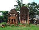 At-chala Shiva temple and Vishnu deul
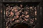 Terracotta panel in the Vishnu deul
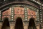 Terracotta panel in the Shiva temple
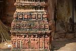 Terracotta work in the Shiva temple
The pictures are a part of Wiki Explores Bankura programme, an initiative by West Bengal Wikimedians User Group
Healthcare
There is a primary health centre at Balsi, with 10 beds.[6]
References
- "CD block Wise Primary Census Abstract Data(PCA)". West Bengal – District-wise CD blocks. Registrar General and Census Commissioner, India. Retrieved 18 April 2020.
- "Balsi HS". Schools.org.in. Retrieved 4 May 2020.
- "Patrasayer Mahavidyalaya". Patrasayer Mahavidyalaya. Archived from the original on 6 January 2017. Retrieved 29 November 2016.
- "Patrasayer Mahaviyalaya". College Admission. Retrieved 6 March 2018.
- McCutchion, David J., Late Mediaeval Temples of Bengal, first published 1972, reprinted 2017, pages 24, 39, 75, 77. The Asiatic Society, Kolkata, ISBN 978-93-81574-65-2
- "Health & Family Welfare Department" (PDF). Health Statistics – Primary Health Centres. Government of West Bengal. Retrieved 10 April 2020.
External links
| Wikimedia Commons has media related to Balsi Purbapara. |
Cities, towns and locations in Bankura District | |||||||
|---|---|---|---|---|---|---|---|
| Cities, municipal and census towns |
| ||||||
| Locations other than cities and towns |
| ||||||
| Related topics |
| ||||||