Laze pri Kostelu
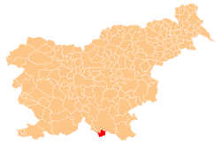
Laze pri Kostelu (pronounced [ˈlaːzɛ pɾi kɔˈsteːlu]) is a small settlement in the Municipality of Kostel in southern Slovenia. It lies in a small valley east of Kuželj. The area is part of the traditional region of Lower Carniola and is now included in the Southeast Slovenia Statistical Region.[2]
Laze pri Kostelu | |
|---|---|
 Laze pri Kostelu Location in Slovenia | |
| Coordinates: 45°28′27.09″N 14°49′27.73″E | |
| Country | |
| Traditional region | Lower Carniola |
| Statistical region | Southeast Slovenia |
| Municipality | Kostel |
| Area | |
| • Total | 2.46 km2 (0.95 sq mi) |
| Elevation | 307.8 m (1,009.8 ft) |
| Population (2002) | |
| • Total | 13 |
| [1] | |
Name
The name of the settlement was changed from Laze to Laze pri Kostelu in 1955.[3]
gollark: Rust isn't as popular.
gollark: No, Ferris has been around for years, and also ew.
gollark: https://www.rust-lang.org/
gollark: <:ferris:749384160715735160>
gollark: Ferris.
References
- Statistical Office of the Republic of Slovenia
- Kostel municipal site
- Spremembe naselij 1948–95. 1996. Database. Ljubljana: Geografski inštitut ZRC SAZU, DZS.
This article is issued from Wikipedia. The text is licensed under Creative Commons - Attribution - Sharealike. Additional terms may apply for the media files.
