Lasiona, Elis
Lasiona (Greek: Λασιώνα) is a former municipality in Elis, West Greece, Greece. Since the 2011 local government reform it is part of the municipality Archaia Olympia, of which it is a municipal unit.[2] The municipal unit has an area of 119.528 km2.[3] Its seat of administration was the village Antroni. Lasiona is situated in a mountainous area on the border with Achaea, 20 km north of Olympia, 27 km northeast of Pyrgos and 50 km south of Patras. The Greek National Road 33 (Patras - Tripoli) passes through the municipal unit.
Lasiona Λασιώνα | |
|---|---|
 Lasiona Location within the regional unit 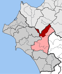 | |
| Coordinates: 37°49′N 21°41′E | |
| Country | Greece |
| Administrative region | West Greece |
| Regional unit | Elis |
| Municipality | Archaia Olympia |
| • Municipal unit | 119.5 km2 (46.1 sq mi) |
| Elevation | 580 m (1,900 ft) |
| Population (2011)[1] | |
| • Municipal unit | 1,312 |
| • Municipal unit density | 11/km2 (28/sq mi) |
| Time zone | UTC+2 (EET) |
| • Summer (DST) | UTC+3 (EEST) |
| Vehicle registration | ΗΑ |
Historical population
| Year | Population |
|---|---|
| 1991 | 2,127 |
| 2001 | 1,915 |
| 2011 | 1,312 |
gollark: I'm working on an alternative trading hub, but:as with all my projects, estimated completion date is next milleniumIt won't work very well due to the DC API being awful and me not having access anyway
gollark: I just don't understand why TJ09 didn't add it originally? Social experiment?Maybe "how bad can I make a feature and keep people using it"?
gollark: Pagination when?
gollark: Well, it is still one of our xenowyrm overlords.
gollark: Cut it into tenths and give 7/10 to someone else.
See also
References
- "Απογραφή Πληθυσμού - Κατοικιών 2011. ΜΟΝΙΜΟΣ Πληθυσμός" (in Greek). Hellenic Statistical Authority.
- Kallikratis law Greece Ministry of Interior (in Greek)
- "Population & housing census 2001 (incl. area and average elevation)" (PDF) (in Greek). National Statistical Service of Greece. Archived from the original (PDF) on 2015-09-21.
This article is issued from Wikipedia. The text is licensed under Creative Commons - Attribution - Sharealike. Additional terms may apply for the media files.