Lapeer, Kansas
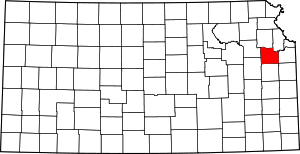
Lapeer is a ghost town in Douglas County, in the U.S. state of Kansas.[2]
Lapeer, Kansas | |
|---|---|
| Coordinates: 38°47′53″N 95°26′46″W[1] | |
| Country | United States |
| State | Kansas |
| County | Douglas |
| Elevation | 1,112 ft (339 m) |
| Population | |
| • Total | 0 |
| Time zone | UTC-6 (CST) |
| • Summer (DST) | UTC-5 (CDT) |
| Area code | 785 |
| GNIS ID | 482174 [1] |
History
Lapeer was founded in 1855 on the Santa Fe Trail route.[3] The community was named after Lapeer, Michigan.[4] The Lapeer post office closed in 1902.[5]
gollark: I just discovered that Elm removed infix operators. Except the special maaaaagic ones in their libraries. *Sigh*.
gollark: DFiscord strips/moves some of the diacritics. A shame.
gollark: ```1͢0ͅ:̻3̕3̂:͑5̇4͒.͈0͘6̴6̡ ͍[͟D̒ĚB̷UͪG̭]͢ ͐F̋a͙i͙l̳e͍d̿ ̬t̨o̓ ̿iͨn̥i͆tͨi̶âl͢i͋z̹ë ̈n͡e̺tͯt͙yͬ-̸t͙c̞n͉ąt͒i̘v̇eͩ;̃ ̦Ö́pͯe͟n͉S͟sͅl̵Eͤn̋g͐i̕n̨ẽ ̽w̻i̴ḻl͏ ̉b͡e̎ ͯȕnͦa̾v͂ài͘l̸a̋b͠l̘e҉.͚ ̉S̐e̱e͓ ̘h͡tͩt̓p̜:͜/ͫ/͜n̮e͉țťy̱.ͧi͆o̾/ͩw͂i̚k͕i̇/̪f̼o̠r̟k͞e̷d͡-ͤt͂o҉m̍c̸a̓ţ-͈n̮a̘t̍i͕v̤e̫.̪h͐t̠m̈́lͭ ̕f̋o̢r̢ ̹m̘o͛r̿e information.java.lang.UnsatisfiedLinkError: io.netty.int҉ernal.tcnative.Library.version(I)I at io.netty.internal.tcnative.Library.version(Native Method) ~[CCEmuX-cct.jar:1.0.0] at io.netty.internal.tcnative.L҉ibrary.in҉itialize(Library.java:126) ~[CCEmuX-cct.jar:1.0.0] at io.netty.i҉nternal.tcnative.Library.initialize(Library.java:109) ~[CCEmuX-cct.jar:1.0.0] at io.netty.handler.ssl.҉OpenSsl.initializeTcNative(OpenSsl.java:389) ~[CCEmuX-cct.jar:1.0.0]```
gollark: ```1͙0̷:̗3̣3̉:̃5̦4͝.͌9̀9̀3͡ ̼[ͩDͥẼB́UͥG̅]̰ ̀-ͯD͓i̾o̗.̋n͜e̠t̛tͬy̐.̥ǹo͗J̺d͓k̟Z̲l̔i̐b̕D̫e̜c̪ö́d͖ĕr̥:̩ ͖f̜a͗lͪs͟e͗1ͬ0̜:͘3͇3͙:̨5̎4͗.ͭ9ͤ9̣4̘ ͈[͞DͪE̹BͪU̇Gͬ]͔ ̓-̑D͉įoͣ.̣n͋e͋t̏t͡y͇.͟nͯóJ҉d̳ḱẐl̈́i͚b̃E̓n͜c͖oͫḑe̸r͒:ͩ ̲f̳ál̤sͯe͊1̃0̤:̘3́3͑:͆5̼5́.̈0̂9͗3͎ ̪[ͨD͌EͨBͤU͐G̉]̨ ͮW̒e̾b̸Şo̲c͚k̇e̳t͏ ͞v͒e͟r̕s̍i̒o̻n͋ ͈1͛3 client handshake key: Y993qHMURPb҉LVatcaluqHQ==, expected response: I+6z21Zl҉cA7ZTDEjSuCwAOd5J3k=10:33:55.131 [DEBUG] WebSocket version 13 client handshake key: NCQFre5ABsrIjtOAWchkXA==, expected response: AUKIPK8Sre+hWth/PRdzUhQB0CA=10:33:55.171 [DEBUG] [id: 0x7d37c46e҉, L:/192.168.1.25:52318 - R:osmarks.tk/86.189.191.201:443] HANDSHAKEN: TLS_ECDHE_RSA_WITH_AES_128_GCM_SHA25610:33:55.186 [DEBUG] [id: 0x66d2d҉6bc, L:/192.168.1.25:52322 - ҉R:osmarks.tk/86.189.191.201:443] HANDSHAKEN: TLS_ECDHE_RSA_WITH_AES_128_GCM_SHA25610:33:55.192 [DEBUG] [id: 0x7de3b170, L:/192.168.1.25:52320 - R:osmarks.tk/86.189.191.201:443] HANDSHAKEN: TLS_ECDHE_RSA_WITH_AES_128_GCM_SHA256```
gollark: ||A||||u||||t||||o||||m||||a||||t||||i||||c|||| ||||s||||p||||o||||i||||l||||e||||r||||i||||s||||a||||t||||i||||o||||n||||.||||T||||h||||i||||s|||| ||||i||||s|||| ||||f||||u||||n||||.||
References
- Geographic Names Information System (GNIS) details for Belvoir, Kansas; United States Geological Survey (USGS); October 13, 1978.
- U.S. Geological Survey Geographic Names Information System: Lapeer (historical)
- Cleland, Nora (Jun 12, 1961). "Only few of 45 county settlements left". Lawrence Journal-World. pp. 13A. Retrieved 1 November 2015.
- History of the State of Kansas: Containing a Full Account of Its Growth from an Uninhabited Territory to a Wealthy and Important State. A. T. Andreas. 1883. p. 360.
- "Douglas County". Jim Forte Postal History. Retrieved 8 April 2015.
This article is issued from Wikipedia. The text is licensed under Creative Commons - Attribution - Sharealike. Additional terms may apply for the media files.


