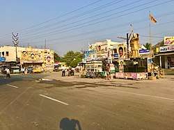
Lam, Guntur district
Lam is a village in Guntur district of the Indian state of Andhra Pradesh. It is located in Tadikonda mandal of Guntur revenue division.[2][4] It forms a part of Andhra Pradesh Capital Region.[5]
Lam | |
|---|---|
Village | |
 Lam Village | |
.svg.png) Lam Location in Andhra Pradesh, India | |
| Coordinates: 16.2257°N 80.2640°E | |
| Country | India |
| State | Andhra Pradesh |
| District | Guntur |
| Mandal | Tadikonda |
| Government | |
| • Type | Panchayati raj |
| • Body | Lam gram panchayat |
| Area | |
| • Total | 1,208 ha (2,985 acres) |
| Population (2011)[3] | |
| • Total | 6,552 |
| • Density | 540/km2 (1,400/sq mi) |
| Languages | |
| • Official | Telugu |
| Time zone | UTC+5:30 (IST) |
| PIN | 522xxx |
| Area code(s) | +91–8663 |
| Vehicle registration | AP |
Etymology
The name originated from Lamas, a Buddhist monk.[6]
Demographics
As of 2011 census, Lam has a population of 6552, of which males are 3207 and females are 3345 with a sex ratio 1043, Child account a population of 762 with 11.63% of total population with a sex ratio of 1117. Literacy rate in Lam is 64.04%.
Government and politics
Lam gram panchayat is the local self-government of the village.[1] It is divided into wards and each ward is represented by a ward member.[7] The ward members are headed by a Sarpanch.[8]
Education
Agricultural University and Regional Agricultural Research Station are the major educational and research establishments in the village. Regional Agricultural Research Station was set up in 1922.Private Institutions like Chalapathi institute of Technology,Chalapathi Pharmaceutical sciences and Delhi Public School are located in the area[6]
See also
References
- "Gram Panchayat Identification Codes" (PDF). Saakshar Bharat Mission. National Informatics Centre. p. 120. Archived from the original (PDF) on 18 August 2017. Retrieved 7 May 2019.
- "District Census Hand Book – Guntur" (PDF). Census of India. Registrar General and Census Commissioner of India. pp. 14, 276. Retrieved 7 May 2019.
- "Population". Census of India. Registrar General and Census Commissioner of India. Retrieved 8 May 2019.
- Murty, M. L. K. (2003). Pre- and Protohistoric Andhra Pradesh Up to 500 B.C. Orient Blackswan. p. 126. ISBN 9788125024750. Retrieved 25 May 2019.
- "Declaration of A.P. Capital Region" (PDF). Andhra Pradesh Capital Region Development Authority. Municipal Administration and Urban Development Department, Andhra Pradesh. 30 December 2014. p. 4. Archived from the original (PDF) on 11 May 2019. Retrieved 17 May 2019.
- "Guntur hogs limelight, bags two Central institutes". The Hindu. 21 December 2015. Retrieved 25 June 2016.
- Seetharam, Mukkavilli (1 January 1990). Citizen Participation in Rural Development. Mittal Publications. p. 34. ISBN 9788170992271.
- Social Science. Vk Publications. p. 117. ISBN 9788179732144.