Laflin, Missouri
Laflin is an unincorporated community in the southeastern part of Lorance Township in Bollinger County, Missouri, United States. The community is on the Crooked Creek floodplain at the end of Missouri Route U. Marble Hill is approximately 4.5 miles to the northwest.[2]
Laflin, Missouri | |
|---|---|
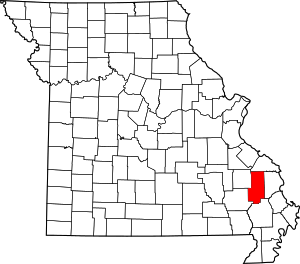 Location of Bollinger County, Missouri | |
| Coordinates: [1] | |
| Country | United States |
| State | Missouri |
| County | Bollinger |
| Township | Lorance |
| Elevation | 400 ft (122 m) |
| Time zone | UTC-6 (Central (CST)) |
| • Summer (DST) | UTC-5 (CDT) |
| Area code(s) | 573 |
History
The community was named after Sylvester M. Laflin, who was then a director of the Belmont Branch of the St. Louis and Iron Mountain Railroad.[3] The community was an important shipping-point for railroad timber.[4] A post office was in operation between 1871–1954.[5]
gollark: Lowercasing is not always valid.
gollark: Nope.
gollark: The difference is about 55 orders of magnitude.
gollark: YB is yottabytes, yb is yoctobits.
gollark: Wrong. Entirely.
References
- U.S. Geological Survey Geographic Names Information System: Laflin, Missouri
- Missouri Atlas & Gazetteer, DeLorme, 1998, First edition, p. 58, ISBN 0-89933-224-2
- State Historical Society of Missouri: Bollinger County Place Names, 1928-1945 http://shs.umsystem.edu/manuscripts/ramsay/ramsay_bollinger.html
- A Directory of Towns, Villages, and Hamlets Past and Present of Bollinger County, Missouri "Archived copy". Archived from the original on 2013-10-29. Retrieved 2013-12-08.CS1 maint: archived copy as title (link)
- Post Offices in Bollinger County, MO "Archived copy". Archived from the original on 2013-10-29. Retrieved 2013-12-08.CS1 maint: archived copy as title (link)
Municipalities and communities of Bollinger County, Missouri, United States | ||
|---|---|---|
| City | Map of Missouri highlighting Bollinger County | |
| Villages | ||
| Townships | ||
| Unincorporated communities | ||
| Abandoned villages | ||
This article is issued from Wikipedia. The text is licensed under Creative Commons - Attribution - Sharealike. Additional terms may apply for the media files.