Lac-Achouakan, Quebec
Lac-Achouakan is an unorganized territory in the Canadian province of Quebec, located in the regional county municipality of Lac-Saint-Jean-Est. It had a population of zero in the Canada 2006 Census, and covered a land area of 227.35 km2,[4] entirely within the Laurentides Wildlife Reserve. The western boundary of the territory is Bark River (Rivière aux Écorces), while Quebec Route 169 forms the eastern boundary.
Lac-Achouakan | |
|---|---|
Unorganized territory | |
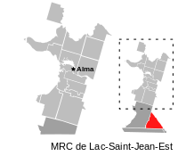 | |
 Lac-Achouakan Location in Saguenay–Lac-Saint-Jean Quebec. | |
| Coordinates: 48°07′N 71°39′W[1] | |
| Country | |
| Province | |
| Region | Saguenay–Lac-Saint-Jean |
| RCM | Lac-Saint-Jean-Est |
| Constituted | January 1, 1986 |
| Government | |
| • Federal riding | Roberval—Lac-Saint-Jean |
| • Prov. riding | Lac-Saint-Jean |
| Area | |
| • Total | 240.90 km2 (93.01 sq mi) |
| • Land | 227.35 km2 (87.78 sq mi) |
| Population (2011)[3] | |
| • Total | 0 |
| • Density | 0.0/km2 (0/sq mi) |
| • Pop 2006-2011 | |
| • Dwellings | 0 |
| Time zone | UTC-5 (EST) |
| • Summer (DST) | UTC-4 (EDT) |
| Highways | |
The eponymous Lake Achouakan (48°06′34″N 71°38′55″W) is near and drains into the Bark River. Its name comes from the Innu-aimun language and means "bridge lake".[5]
References
- Reference number 149748 of the Commission de toponymie du Québec (in French)
- Ministère des Affaires municipales, des Régions et de l'Occupation du territoire - Répertoire des municipalités: Lac-Achouakan
- "Lac-Achouakan census profile". 2011 Census data. Statistics Canada. Retrieved 2010-10-29.
- Canada 2006 Census Community Profiles: Lac-Achouakan. Statistics Canada.
- "Lac Achouakan" (in French). Commission de toponymie du Québec. Retrieved 2010-10-29.
Adjacent Municipal Subdivisions | ||||||||||
|---|---|---|---|---|---|---|---|---|---|---|
| ||||||||||
| Cities | |
|---|---|
| Municipalities |
|
| Parishes | |
| Villages | |
| Unorganized territories | |
| |
This article is issued from Wikipedia. The text is licensed under Creative Commons - Attribution - Sharealike. Additional terms may apply for the media files.