La Patrie, Quebec
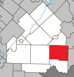
La Patrie is a municipality of about 750 people in Le Haut-Saint-François Regional County Municipality, in Quebec, Canada. It is located at the base of Mont Mégantic.
La Patrie | |
|---|---|
Municipality | |
 Location within Le Haut-Saint-François RCM. | |
 La Patrie Location in southern Quebec. | |
| Coordinates: 45°24′N 71°15′W[1] | |
| Country | |
| Province | |
| Region | Estrie |
| RCM | Le Haut-Saint-François |
| Constituted | December 24, 1997 |
| Government | |
| • Mayor | Jacques Blais |
| • Federal riding | Compton—Stanstead |
| • Prov. riding | Mégantic |
| Area | |
| • Total | 206.70 km2 (79.81 sq mi) |
| • Land | 205.82 km2 (79.47 sq mi) |
| Population (2011)[3] | |
| • Total | 749 |
| • Density | 3.6/km2 (9/sq mi) |
| • Pop 2006-2011 | |
| Time zone | UTC−5 (EST) |
| • Summer (DST) | UTC−4 (EDT) |
| Postal code(s) | J0B 1Y0 |
| Area code(s) | 819 |
| Highways | |
| Website | www |
Some industries specializing in the field of forestry have settled in La Patrie. The company Guitabec, which produces guitars under the label Godin, has a manufacturing facility in La Patrie.
Light pollution
Participating in a program initiated and established by the Mont-Mégantic National Park in collaboration with Hydro-Québec, the village of La Patrie has greatly reduced its light pollution, which strongly affects the Mont Mégantic Observatory.
gollark: I have an extension which lets me force open things as text/image/video.
gollark: It knows me so* well!
gollark: ++remind 1y Bye epicbot
gollark: +>markov
gollark: +>markov
References
- Reference number 339393 of the Commission de toponymie du Québec (in French)
- Geographic code 41027 in the official Répertoire des municipalités (in French)
- "(Code 2441027) Census Profile". 2011 census. Statistics Canada. 2012.
This article is issued from Wikipedia. The text is licensed under Creative Commons - Attribution - Sharealike. Additional terms may apply for the media files.