Lázaro Cárdenas, Jalisco
Lázaro Cárdenas (Spanish: [ˈlasaɾo ˈkaɾðenas] (![]()
Lázaro Cárdenas | |
|---|---|
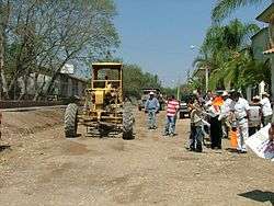
 The inauguration of Lázaro Cárdenas' highway. | |
 Seal | |
| Nickname(s): Cárdenas | |
| Coordinates: 20°26′30″N 103°58′08″W | |
| Country | |
| State | |
| Municipality | San Martín de Hidalgo |
| Established | April 9, 1937 |
| Government | |
| • Type | Municipal Agency |
| • Municipal Agent | Bertha Alicia Hernandez Guardado |
| • Sub-agent | Jose Isac Ramos Ruelas |
| Elevation | 1,325 m (4,348 ft) |
| Population (2010) | |
| • Total | 297 |
| Time zone | UTC-6 (Central Standard Time) |
| • Summer (DST) | UTC-5 (Central Daylight Time) |
History
Prior to 1937, the area was known as Rancho 'El Camichín', a land grant owned by Jesús Rosas. The land was donated by Rosas with the purpose of constructing a townsite. Many of the people residing in the nearby town of San Jerónimo, migrated to acquire lands in the town. The town was officially established with a document[1] signed on April 9, 1937 by the governor and residents dictating that the new name would be "Lázaro Cárdenas", in honor of Lázaro Cárdenas del Río, President of Mexico from Michoacán (1934–1940).
Population
As of the INEGI census of 2005, there were 235 people residing in Lázaro Cárdenas. 115 of them being male, and 120 of them being female.
References
- The document was published on a website of the municipality, it also has many signatures of various residents of adjacent towns.
