Kysak
Kysak (Hungarian: Sároskőszeg) is a village and railway hub in Košice-okolie District in the Košice Region of eastern Slovakia.
Kysak | |
|---|---|
Village | |
 | |
 Coat of arms | |
 Kysak Location of Kysak in Slovakia | |
| Coordinates: 48°51′30″N 21°13′00″E | |
| Country | Slovakia |
| Region | Košice |
| District | Košice-okolie |
| First mentioned | 1330 |
| Area | |
| • Total | 10.865 km2 (4.195 sq mi) |
| Elevation | 298 m (978 ft) |
| Population (2005-12-31) | |
| • Total | 1,390 |
| • Density | 130/km2 (330/sq mi) |
| Time zone | UTC+1 (CET) |
| • Summer (DST) | UTC+2 (CEST) |
| Postal code | 044 81 |
| Area code(s) | +421-55 |
| Car plate | KS |
| Website | www.kysak.sk |
History
Historically, the village was first mentioned in 1330. There is a monument as a memory of the soldiers killed in the first and second World Wars.
Geography
The village lies at an altitude of 298 metres and covers an area of 10.865 km².
Population
The municipality has a population of about 1390 people.
Transport
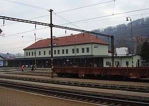
Kysak railway station is an important railway junction, where the Košice–Plaveč–Čirč–Muszyna railway diverges towards Poland from the Košice–Žilina railway, which is part of Slovakia's main east-west rail corridor.
gollark: Replying to https://discord.com/channels/198130613759246337/198142140805677065/746856978365808731I mean, my things just use dynmap for player tracking directly.
gollark: By which I mean "swapped out a tiny bit of the signal processing frontend and display logic", but you know.
gollark: Well, yes, I rewrote my software to track those.
gollark: Anonymized GPS may have removed anavrins' ability to locate random turtles, and also only exist because of me finding out about that probably quite a while after him and writing a proof of concept global tracking system, but is probably good for CC privacy.
gollark: I hope they copied the potatOS backdoors in GPS too!
External links
- Municipal website (in Slovak)
This article is issued from Wikipedia. The text is licensed under Creative Commons - Attribution - Sharealike. Additional terms may apply for the media files.