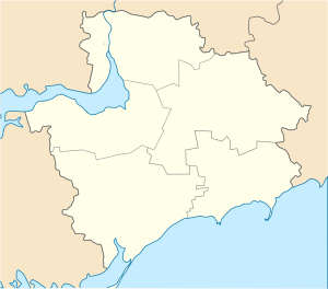
Kushuhum
Kushuhum or Kushugum (Ukrainian: Кушугум) is an urban-type settlement in the Zaporizhia Raion (district) of Zaporizhia Oblast in southern Ukraine. Population: 8,258 (2013 est.)[2]. In 2001, its population was 5,668 according to the census,[3] Kushuhum is the administrative center of the Kushuhum Council, a local government area.[3]
Kushuhum Кушугум | |
|---|---|
 Kushuhum Location of Kushuhum in Zaporizhia Oblast  Kushuhum Kushuhum (Zaporizhia Oblast) | |
| Coordinates: 47°42′38″N 35°13′09″E | |
| Country | |
| Province | Zaporizhia Oblast |
| District | Zaporizhia Raion |
| Founded | 1770 |
| Settlement status | 1938 |
| Area | |
| • Total | 4.499 km2 (1.737 sq mi) |
| Elevation | 60 m (200 ft) |
| Population (2013) | |
| • Total | |
| Time zone | UTC+2 (EET) |
| • Summer (DST) | UTC+3 (EEST) |
| Postal code | 70450–451 |
| Area code | +380 61 |
| Climate | Dfa |
| Website | http://rada.gov.ua/ |
The settlement was first founded in 1770 as the village of Velyka Katerynivka (Ukrainian: Велика Катеринівка). In 1938, it was renamed to Kushuhum and given the status of an urban-type settlement.[3] It is located on the left bank of the Kakhovka Reservoir.
References
- "Kushuhum (Zaporizhia Oblast, Zaporizhia Raion)". weather.in.ua. Retrieved 14 January 2015.
- Чисельність наявного населення України [Actual population of Ukraine] (in Ukrainian). State Statistics Service of Ukraine. Retrieved 21 January 2015.
- "Kushuhum, Zaporizhia Oblast, Zaporizhia Raion". Regions of Ukraine and their Structure (in Ukrainian). Verkhovna Rada of Ukraine. Retrieved 14 January 2015.
This article is issued from Wikipedia. The text is licensed under Creative Commons - Attribution - Sharealike. Additional terms may apply for the media files.