Kurkura
Kurkura is a town and a municipal committee in Khunti district in the Indian state of Jharkhand. The town is located about 143 km from Ranchi on National Highway 1 and is well connected to rail routes as well.
Kurkura | |
|---|---|
Town | |
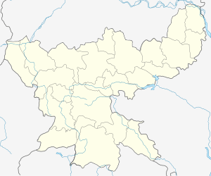
 Kurkura Location in Jharkhand, India  Kurkura Kurkura (India) | |
| Coordinates: 22.80°N 84.92°E | |
| Country | |
| State | Jharkhand |
| District | Simdega |
| Elevation | 465 m (1,526 ft) |
| Population (2001) | |
| • Total | 900 |
| Languages | |
| • Official | Hindi |
| Time zone | UTC+5:30 (IST) |
| Telephone code | +91-01-XXXXXX |
| Vehicle registration | JH |
| Sex Ratio | 996:1000 ♂/♀ |
History
Geography
Kurkura is located at 22°48′16″N 84°55′16″E southern Jharkhand.
Transport
Kurkura is well connected via Rail and Road routes.
Roadways
Kurakura is well connected to other cities by district road Salgutu — Kurkura Road.
gollark: <:chips:453465151132139521><:chips:453465151132139521><:chips:453465151132139521><:chips:453465151132139521><:chips:453465151132139521><:chips:453465151132139521><:chips:453465151132139521><:chips:453465151132139521><:chips:453465151132139521><:chips:453465151132139521><:chips:453465151132139521><:chips:453465151132139521><:chips:453465151132139521><:chips:453465151132139521><:chips:453465151132139521><:chips:453465151132139521><:chips:453465151132139521><:chips:453465151132139521><:chips:453465151132139521><:chips:453465151132139521><:chips:453465151132139521><:chips:453465151132139521><:chips:453465151132139521><:chips:453465151132139521><:chips:453465151132139521><:chips:453465151132139521><:chips:453465151132139521><:chips:453465151132139521><:chips:453465151132139521><:chips:453465151132139521><:chips:453465151132139521><:chips:453465151132139521><:chips:453465151132139521><:chips:453465151132139521><:chips:453465151132139521><:chips:453465151132139521><:chips:453465151132139521><:chips:453465151132139521><:chips:453465151132139521><:chips:453465151132139521><:chips:453465151132139521><:chips:453465151132139521><:chips:453465151132139521><:chips:453465151132139521><:chips:453465151132139521><:chips:453465151132139521><:chips:453465151132139521><:chips:453465151132139521><:chips:453465151132139521><:chips:453465151132139521><:chips:453465151132139521><:chips:453465151132139521><:chips:453465151132139521><:chips:453465151132139521><:chips:453465151132139521><:chips:453465151132139521><:chips:453465151132139521><:chips:453465151132139521><:chips:453465151132139521><:chips:453465151132139521><:chips:453465151132139521><:chips:453465151132139521><:chips:453465151132139521><:chips:453465151132139521><:chips:453465151132139521><:chips:453465151132139521><:chips:453465151132139521><:chips:453465151132139521><:chips:453465151132139521><:chips:453465151132139521><:chips:453465151132139521><:chips:453465151132139521><:chips:453465151132139521><:chips:453465151132139521>
gollark: <:chips:453465151132139521><:chips:453465151132139521><:chips:453465151132139521><:chips:453465151132139521><:chips:453465151132139521><:chips:453465151132139521><:chips:453465151132139521><:chips:453465151132139521><:chips:453465151132139521><:chips:453465151132139521><:chips:453465151132139521><:chips:453465151132139521><:chips:453465151132139521><:chips:453465151132139521><:chips:453465151132139521><:chips:453465151132139521><:chips:453465151132139521><:chips:453465151132139521><:chips:453465151132139521><:chips:453465151132139521><:chips:453465151132139521><:chips:453465151132139521><:chips:453465151132139521><:chips:453465151132139521><:chips:453465151132139521><:chips:453465151132139521><:chips:453465151132139521><:chips:453465151132139521><:chips:453465151132139521><:chips:453465151132139521><:chips:453465151132139521><:chips:453465151132139521><:chips:453465151132139521><:chips:453465151132139521><:chips:453465151132139521><:chips:453465151132139521><:chips:453465151132139521><:chips:453465151132139521><:chips:453465151132139521><:chips:453465151132139521><:chips:453465151132139521><:chips:453465151132139521><:chips:453465151132139521><:chips:453465151132139521><:chips:453465151132139521><:chips:453465151132139521><:chips:453465151132139521><:chips:453465151132139521><:chips:453465151132139521><:chips:453465151132139521><:chips:453465151132139521><:chips:453465151132139521><:chips:453465151132139521><:chips:453465151132139521><:chips:453465151132139521><:chips:453465151132139521><:chips:453465151132139521><:chips:453465151132139521><:chips:453465151132139521><:chips:453465151132139521><:chips:453465151132139521><:chips:453465151132139521><:chips:453465151132139521><:chips:453465151132139521><:chips:453465151132139521><:chips:453465151132139521><:chips:453465151132139521><:chips:453465151132139521><:chips:453465151132139521><:chips:453465151132139521><:chips:453465151132139521><:chips:453465151132139521><:chips:453465151132139521><:chips:453465151132139521>
gollark: <:chips:453465151132139521><:chips:453465151132139521><:chips:453465151132139521><:chips:453465151132139521><:chips:453465151132139521><:chips:453465151132139521><:chips:453465151132139521><:chips:453465151132139521><:chips:453465151132139521><:chips:453465151132139521><:chips:453465151132139521><:chips:453465151132139521><:chips:453465151132139521><:chips:453465151132139521><:chips:453465151132139521><:chips:453465151132139521><:chips:453465151132139521><:chips:453465151132139521><:chips:453465151132139521><:chips:453465151132139521><:chips:453465151132139521><:chips:453465151132139521><:chips:453465151132139521><:chips:453465151132139521><:chips:453465151132139521><:chips:453465151132139521><:chips:453465151132139521><:chips:453465151132139521><:chips:453465151132139521><:chips:453465151132139521><:chips:453465151132139521><:chips:453465151132139521><:chips:453465151132139521><:chips:453465151132139521><:chips:453465151132139521><:chips:453465151132139521><:chips:453465151132139521><:chips:453465151132139521><:chips:453465151132139521><:chips:453465151132139521><:chips:453465151132139521><:chips:453465151132139521><:chips:453465151132139521><:chips:453465151132139521><:chips:453465151132139521><:chips:453465151132139521><:chips:453465151132139521><:chips:453465151132139521><:chips:453465151132139521><:chips:453465151132139521><:chips:453465151132139521><:chips:453465151132139521><:chips:453465151132139521><:chips:453465151132139521><:chips:453465151132139521><:chips:453465151132139521><:chips:453465151132139521><:chips:453465151132139521><:chips:453465151132139521><:chips:453465151132139521><:chips:453465151132139521><:chips:453465151132139521><:chips:453465151132139521><:chips:453465151132139521><:chips:453465151132139521><:chips:453465151132139521><:chips:453465151132139521><:chips:453465151132139521><:chips:453465151132139521><:chips:453465151132139521><:chips:453465151132139521><:chips:453465151132139521><:chips:453465151132139521><:chips:453465151132139521>
gollark: <:chips:453465151132139521><:chips:453465151132139521><:chips:453465151132139521><:chips:453465151132139521><:chips:453465151132139521><:chips:453465151132139521><:chips:453465151132139521><:chips:453465151132139521><:chips:453465151132139521><:chips:453465151132139521><:chips:453465151132139521><:chips:453465151132139521><:chips:453465151132139521><:chips:453465151132139521><:chips:453465151132139521><:chips:453465151132139521><:chips:453465151132139521><:chips:453465151132139521><:chips:453465151132139521><:chips:453465151132139521><:chips:453465151132139521><:chips:453465151132139521><:chips:453465151132139521><:chips:453465151132139521><:chips:453465151132139521><:chips:453465151132139521><:chips:453465151132139521><:chips:453465151132139521><:chips:453465151132139521><:chips:453465151132139521><:chips:453465151132139521><:chips:453465151132139521><:chips:453465151132139521><:chips:453465151132139521><:chips:453465151132139521><:chips:453465151132139521><:chips:453465151132139521><:chips:453465151132139521><:chips:453465151132139521><:chips:453465151132139521><:chips:453465151132139521><:chips:453465151132139521><:chips:453465151132139521><:chips:453465151132139521><:chips:453465151132139521><:chips:453465151132139521><:chips:453465151132139521><:chips:453465151132139521><:chips:453465151132139521><:chips:453465151132139521><:chips:453465151132139521><:chips:453465151132139521><:chips:453465151132139521><:chips:453465151132139521><:chips:453465151132139521><:chips:453465151132139521><:chips:453465151132139521><:chips:453465151132139521><:chips:453465151132139521><:chips:453465151132139521><:chips:453465151132139521><:chips:453465151132139521><:chips:453465151132139521><:chips:453465151132139521><:chips:453465151132139521><:chips:453465151132139521><:chips:453465151132139521><:chips:453465151132139521><:chips:453465151132139521><:chips:453465151132139521><:chips:453465151132139521><:chips:453465151132139521><:chips:453465151132139521><:chips:453465151132139521>
gollark: <:chips:453465151132139521><:chips:453465151132139521><:chips:453465151132139521><:chips:453465151132139521><:chips:453465151132139521><:chips:453465151132139521><:chips:453465151132139521><:chips:453465151132139521><:chips:453465151132139521><:chips:453465151132139521><:chips:453465151132139521><:chips:453465151132139521><:chips:453465151132139521><:chips:453465151132139521><:chips:453465151132139521><:chips:453465151132139521><:chips:453465151132139521><:chips:453465151132139521><:chips:453465151132139521><:chips:453465151132139521><:chips:453465151132139521><:chips:453465151132139521><:chips:453465151132139521><:chips:453465151132139521><:chips:453465151132139521><:chips:453465151132139521><:chips:453465151132139521><:chips:453465151132139521><:chips:453465151132139521><:chips:453465151132139521><:chips:453465151132139521><:chips:453465151132139521><:chips:453465151132139521><:chips:453465151132139521><:chips:453465151132139521><:chips:453465151132139521><:chips:453465151132139521><:chips:453465151132139521><:chips:453465151132139521><:chips:453465151132139521><:chips:453465151132139521><:chips:453465151132139521><:chips:453465151132139521><:chips:453465151132139521><:chips:453465151132139521><:chips:453465151132139521><:chips:453465151132139521><:chips:453465151132139521><:chips:453465151132139521><:chips:453465151132139521><:chips:453465151132139521><:chips:453465151132139521><:chips:453465151132139521><:chips:453465151132139521><:chips:453465151132139521><:chips:453465151132139521><:chips:453465151132139521><:chips:453465151132139521><:chips:453465151132139521><:chips:453465151132139521><:chips:453465151132139521><:chips:453465151132139521><:chips:453465151132139521><:chips:453465151132139521><:chips:453465151132139521><:chips:453465151132139521><:chips:453465151132139521><:chips:453465151132139521><:chips:453465151132139521><:chips:453465151132139521><:chips:453465151132139521><:chips:453465151132139521><:chips:453465151132139521><:chips:453465151132139521>
References
- "Kurkura/KRKR – KRKR train arrival and departure times — Train Time.In". train-time.in. Retrieved 21 August 2014.
- "Panoramio — Photo of kurkura station jharkhand". panoramio.com. Retrieved 21 August 2014.
This article is issued from Wikipedia. The text is licensed under Creative Commons - Attribution - Sharealike. Additional terms may apply for the media files.