Kunhar River
The Kunhar River (Urdu: دریائے کنہار) or River Kunhar, is 166 kilometres (103 mi) long river, located primarily in the Khyber Pakhtunkhwa province, northern Pakistan. It is in the Indus River watershed basin.
| Kunhar | |
|---|---|
 The river in northern Pakistan | |
| Location | |
| Country | Pakistan |
| province | Khyber Pakhtunkhwa |
| District | Mansehra District |
| Physical characteristics | |
| Source | Lulusar lake |
| • elevation | 3,950 m (12,960 ft) |
| Mouth | Jhelum River |
• location | Muzaffarabad |
| Length | 166 km (103 mi) |
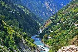
Kunhar River in the Kaghan Valley, Khyber Pakhtunkhwa, Pakistan.
Origin and route
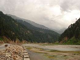
The view of River Kunhar flowing from Tehsil Balakot, District Mansehra during winters.
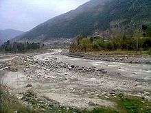
The river originates from the upper Kaghan Valley's Dharamsar Lake, near Babusar Pass. Waters of Dudipat and Saiful Muluk Lakes feed the river besides glacial waters from Malka Parbat and other high peaks in the valley. River Kunhar flows through the entire Kaghan valley (Upper and Lower) and enters into Nainsukh Valley from Balakot comprising Garhi Habibullah and Dalola. The river confluences with Jhelum River at Rarah about 10 km downstream from Muzaffarabad, in the Azad Jammu and Kashmir State, Pakistan.
gollark: Are there ones for other binary formats?
gollark: It's a C program, thus no.
gollark: Yes, it is HIGHLY `-rwxr-xr-x`.
gollark: I thought it might be a filesystem issue of some sort, but then it would just not see it at all, surely?
gollark: Troubling!
See also
References
External links
| Wikimedia Commons has media related to Saiful Muluk Lake. |
| Wikimedia Commons has media related to Kunhar River. |
This article is issued from Wikipedia. The text is licensed under Creative Commons - Attribution - Sharealike. Additional terms may apply for the media files.