Kundol Lake
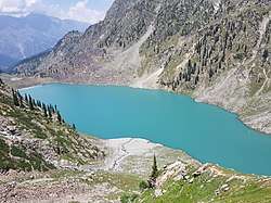
Kundol Lake (Urdu: کنڈول جھیل) also known as Kundol Dand, is a lake in Swat Valley, Khyber Pakhtunkhwa, Pakistan, which is located in the north of Utror valley at a distance of 20.8 kilometres (12.9 mi) away from Kalam.[2] Similarly, there is a well known story about the lake which is that every night in a month, a golden bowl appears in the center of the lake and glistens like moon but no one has ever touched that bowl due to magical powers inside it.
| Kundol Lake | |
|---|---|
 Kundol Lake, Swat Valley | |
 Kundol Lake | |
| Location | Utror Valley, Swat Valley |
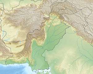
| Coordinates | 35.419°N 72.433°E |
| Lake type | Glacial lake |
| Native name | کنڈول جھیل (Urdu) |
| Primary inflows | Glaciers water |
| Primary outflows | Utror stream |
| Basin countries | Pakistan |
| Max. length | 1.5 km (0.93 mi) |
| Max. width | approx 1 km (0.62 mi) |
| Surface elevation | 3,032.7 m (9,950 ft) [1] |
| Settlements | Utror, Kalam |
Location & Trail to the lake

Kundol Lake lies in the lap of Hindu kush mountains at an elevation of (9,950 ft), in the north of Utror, encompassed by snow clad mountains and towering trees. Similarly, the trail to the lake from Ladu is easy to follow as a large stream flows down from the lake, which merges with River Swat in Kalam valley. It leads beside the stream and takes you to the lake. On the way, lush green forests, picturesque spots and gushing waterfalls welcome one's to the region. The mountains around the lake are covered by thick blanket of vegetation that enhances the beauty of the lake very much. The margins of kundol lake serve as the camping site during the summer season for the trekkers.[3]
Kundol lake is fed by melting glaciers and springs of the Mount Hindu kush. It gives rise to utror Khwar, the major right tributary of the Swat River.[4]
Access
Kundol Lake is accessible only during the summer; during the winter, the roads are closed due to heavy snowfall. It can be accessed by unmetalled road from Kalam up to Utror in a four-wheel automotive where a link road ends in a green valley called Ladu in the foothills of the mountain. Earlier, jeeps used to go till a higher village called Ladu but now bridge and jeep track is destroyed due to floods and rains. One way track time is around 2 to 3hrs till the lake. There are also small refreshment huts in Ladu valley where one can take tea and get something for eating. From Ladu it takes almost four to six hours to reach the lake. The mountains around this small valley are covered with tall cedar and pine trees.
See also
| Wikimedia Commons has media related to Kundol Lake. |
- Lake Saiful Muluk - Kaghan Valley
- Dudipatsar Lake - Kaghan Valley
- Katora Lake - Kumrat Valley
- Mahodand Lake - Kalam Valley
- Daral Lake - Swat Valley
- List of lakes in Pakistan
References
- "Surface Elevation of Lake". www.pakifunda.com. Retrieved 11 June 2018.
- "Distance from Kalam". Google Maps. Retrieved 11 June 2018.
- "Location and Trail". Swatvalley.pk. Retrieved 11 June 2018.
- "Fed by Melting Glaciers and Springs". www.pakistanitourism.com. Retrieved 11 June 2018.
Watch Kundol Lake Video on Youtube : https://www.youtube.com/watch?v=W7EsBwiXNIY