Kunavaram
Kunavaram is a village in East Godavari district, Andhra Pradesh.[1] Kunavaram was a part of Khammam district of then newly formed Telangana until the transfer of 7 mandals including it to then newly formed Andhra Pradesh.[2]
Kunavaram | |
|---|---|
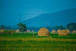
 Paddy Fields near Kunavaram | |
.svg.png) Kunavaram Location in Andhra Pradesh, India  Kunavaram Kunavaram (India) | |
| Coordinates: 17.5833°N 81.2667°E | |
| Country | |
| State | Andhra Pradesh |
| District | East Godavari |
| Government | |
| • Type | Andhra Pradesh State Government |
| Languages | |
| • Official | Telugu |
| Time zone | UTC+5:30 (IST) |
| Vehicle registration | AP |
| Climate | hot (Köppen) |
Geography
Kunavaram is located at 17.5833°N 81.2667°E.[3] It has an average elevation of 28 metres (95 ft).
gollark: ++delete <:Thonk:445016973798014987> <:Thonkdown:433149076721238016> <:Thonk:445016973798014987> <:Thonkdown:433149076721238016> <:Thonk:445016973798014987> <:Thonkdown:433149076721238016> <:Thonk:445016973798014987> <:Thonkdown:433149076721238016> <:Thonk:445016973798014987> <:Thonkdown:433149076721238016> <:Thonk:445016973798014987> <:Thonkdown:433149076721238016> <:Thonk:445016973798014987> <:Thonkdown:433149076721238016> <:Thonk:445016973798014987> <:Thonkdown:433149076721238016> <:Thonk:445016973798014987> <:Thonkdown:433149076721238016> <:Thonk:445016973798014987> <:Thonkdown:433149076721238016> <:Thonk:445016973798014987> <:Thonkdown:433149076721238016> <:Thonk:445016973798014987> <:Thonkdown:433149076721238016> <:Thonk:445016973798014987> <:Thonkdown:433149076721238016> <:Thonk:445016973798014987> <:Thonkdown:433149076721238016> <:Thonk:445016973798014987> <:Thonkdown:433149076721238016> <:Thonk:445016973798014987> <:Thonkdown:433149076721238016> <:Thonk:445016973798014987> <:Thonkdown:433149076721238016> <:Thonk:445016973798014987> <:Thonkdown:433149076721238016> <:Thonk:445016973798014987> <:Thonkdown:433149076721238016> <:Thonk:445016973798014987> <:Thonkdown:433149076721238016> <:Thonk:445016973798014987> <:Thonkdown:433149076721238016> <:Thonk:445016973798014987> <:Thonkdown:433149076721238016> <:Thonk:445016973798014987> <:Thonkdown:433149076721238016> <:Thonk:445016973798014987> <:Thonkdown:433149076721238016> <:Thonk:445016973798014987> <:Thonkdown:433149076721238016> <:Thonk:445016973798014987> <:Thonkdown:433149076721238016> <:Thonk:445016973798014987> <:Thonkdown:433149076721238016> <:Thonk:445016973798014987> <:Thonkdown:433149076721238016> <:Thonk:445016973798014987> <:Thonkdown:433149076721238016> <:Thonk:445016973798014987> <:Thonkdown:433149076721238016> <:Thonk:445016973798014987> <:Thonkdown:433149076721238016> <:Thonk:445016973798014987> <:Thonkdown:433149076721238016>
gollark: ++delete <:Thonk:445016973798014987> <:Thonkdown:433149076721238016> <:Thonk:445016973798014987> <:Thonkdown:433149076721238016> <:Thonk:445016973798014987> <:Thonkdown:433149076721238016> <:Thonk:445016973798014987> <:Thonkdown:433149076721238016> <:Thonk:445016973798014987> <:Thonkdown:433149076721238016> <:Thonk:445016973798014987> <:Thonkdown:433149076721238016> <:Thonk:445016973798014987> <:Thonkdown:433149076721238016> <:Thonk:445016973798014987> <:Thonkdown:433149076721238016> <:Thonk:445016973798014987> <:Thonkdown:433149076721238016> <:Thonk:445016973798014987> <:Thonkdown:433149076721238016> <:Thonk:445016973798014987> <:Thonkdown:433149076721238016> <:Thonk:445016973798014987> <:Thonkdown:433149076721238016> <:Thonk:445016973798014987> <:Thonkdown:433149076721238016> <:Thonk:445016973798014987> <:Thonkdown:433149076721238016> <:Thonk:445016973798014987> <:Thonkdown:433149076721238016> <:Thonk:445016973798014987> <:Thonkdown:433149076721238016> <:Thonk:445016973798014987> <:Thonkdown:433149076721238016> <:Thonk:445016973798014987> <:Thonkdown:433149076721238016> <:Thonk:445016973798014987> <:Thonkdown:433149076721238016> <:Thonk:445016973798014987> <:Thonkdown:433149076721238016> <:Thonk:445016973798014987> <:Thonkdown:433149076721238016> <:Thonk:445016973798014987> <:Thonkdown:433149076721238016> <:Thonk:445016973798014987> <:Thonkdown:433149076721238016> <:Thonk:445016973798014987> <:Thonkdown:433149076721238016> <:Thonk:445016973798014987> <:Thonkdown:433149076721238016> <:Thonk:445016973798014987> <:Thonkdown:433149076721238016> <:Thonk:445016973798014987> <:Thonkdown:433149076721238016> <:Thonk:445016973798014987> <:Thonkdown:433149076721238016> <:Thonk:445016973798014987> <:Thonkdown:433149076721238016> <:Thonk:445016973798014987> <:Thonkdown:433149076721238016> <:Thonk:445016973798014987> <:Thonkdown:433149076721238016> <:Thonk:445016973798014987> <:Thonkdown:433149076721238016>
gollark: ++delete <:Thonk:445016973798014987> <:Thonkdown:433149076721238016> <:Thonk:445016973798014987> <:Thonkdown:433149076721238016> <:Thonk:445016973798014987> <:Thonkdown:433149076721238016> <:Thonk:445016973798014987> <:Thonkdown:433149076721238016> <:Thonk:445016973798014987> <:Thonkdown:433149076721238016> <:Thonk:445016973798014987> <:Thonkdown:433149076721238016> <:Thonk:445016973798014987> <:Thonkdown:433149076721238016> <:Thonk:445016973798014987> <:Thonkdown:433149076721238016> <:Thonk:445016973798014987> <:Thonkdown:433149076721238016> <:Thonk:445016973798014987> <:Thonkdown:433149076721238016> <:Thonk:445016973798014987> <:Thonkdown:433149076721238016> <:Thonk:445016973798014987> <:Thonkdown:433149076721238016> <:Thonk:445016973798014987> <:Thonkdown:433149076721238016> <:Thonk:445016973798014987> <:Thonkdown:433149076721238016> <:Thonk:445016973798014987> <:Thonkdown:433149076721238016> <:Thonk:445016973798014987> <:Thonkdown:433149076721238016> <:Thonk:445016973798014987> <:Thonkdown:433149076721238016> <:Thonk:445016973798014987> <:Thonkdown:433149076721238016> <:Thonk:445016973798014987> <:Thonkdown:433149076721238016> <:Thonk:445016973798014987> <:Thonkdown:433149076721238016> <:Thonk:445016973798014987> <:Thonkdown:433149076721238016> <:Thonk:445016973798014987> <:Thonkdown:433149076721238016> <:Thonk:445016973798014987> <:Thonkdown:433149076721238016> <:Thonk:445016973798014987> <:Thonkdown:433149076721238016> <:Thonk:445016973798014987> <:Thonkdown:433149076721238016> <:Thonk:445016973798014987> <:Thonkdown:433149076721238016> <:Thonk:445016973798014987> <:Thonkdown:433149076721238016> <:Thonk:445016973798014987> <:Thonkdown:433149076721238016> <:Thonk:445016973798014987> <:Thonkdown:433149076721238016> <:Thonk:445016973798014987> <:Thonkdown:433149076721238016> <:Thonk:445016973798014987> <:Thonkdown:433149076721238016> <:Thonk:445016973798014987> <:Thonkdown:433149076721238016>
gollark: ++delete <:Thonk:445016973798014987> <:Thonkdown:433149076721238016> <:Thonk:445016973798014987> <:Thonkdown:433149076721238016> <:Thonk:445016973798014987> <:Thonkdown:433149076721238016> <:Thonk:445016973798014987> <:Thonkdown:433149076721238016> <:Thonk:445016973798014987> <:Thonkdown:433149076721238016> <:Thonk:445016973798014987> <:Thonkdown:433149076721238016> <:Thonk:445016973798014987> <:Thonkdown:433149076721238016> <:Thonk:445016973798014987> <:Thonkdown:433149076721238016> <:Thonk:445016973798014987> <:Thonkdown:433149076721238016> <:Thonk:445016973798014987> <:Thonkdown:433149076721238016> <:Thonk:445016973798014987> <:Thonkdown:433149076721238016> <:Thonk:445016973798014987> <:Thonkdown:433149076721238016> <:Thonk:445016973798014987> <:Thonkdown:433149076721238016> <:Thonk:445016973798014987> <:Thonkdown:433149076721238016> <:Thonk:445016973798014987> <:Thonkdown:433149076721238016> <:Thonk:445016973798014987> <:Thonkdown:433149076721238016> <:Thonk:445016973798014987> <:Thonkdown:433149076721238016> <:Thonk:445016973798014987> <:Thonkdown:433149076721238016> <:Thonk:445016973798014987> <:Thonkdown:433149076721238016> <:Thonk:445016973798014987> <:Thonkdown:433149076721238016> <:Thonk:445016973798014987> <:Thonkdown:433149076721238016> <:Thonk:445016973798014987> <:Thonkdown:433149076721238016> <:Thonk:445016973798014987> <:Thonkdown:433149076721238016> <:Thonk:445016973798014987> <:Thonkdown:433149076721238016> <:Thonk:445016973798014987> <:Thonkdown:433149076721238016> <:Thonk:445016973798014987> <:Thonkdown:433149076721238016> <:Thonk:445016973798014987> <:Thonkdown:433149076721238016> <:Thonk:445016973798014987> <:Thonkdown:433149076721238016> <:Thonk:445016973798014987> <:Thonkdown:433149076721238016> <:Thonk:445016973798014987> <:Thonkdown:433149076721238016> <:Thonk:445016973798014987> <:Thonkdown:433149076721238016> <:Thonk:445016973798014987> <:Thonkdown:433149076721238016>
gollark: ++delete <:Thonk:445016973798014987> <:Thonkdown:433149076721238016> <:Thonk:445016973798014987> <:Thonkdown:433149076721238016> <:Thonk:445016973798014987> <:Thonkdown:433149076721238016> <:Thonk:445016973798014987> <:Thonkdown:433149076721238016> <:Thonk:445016973798014987> <:Thonkdown:433149076721238016> <:Thonk:445016973798014987> <:Thonkdown:433149076721238016> <:Thonk:445016973798014987> <:Thonkdown:433149076721238016> <:Thonk:445016973798014987> <:Thonkdown:433149076721238016> <:Thonk:445016973798014987> <:Thonkdown:433149076721238016> <:Thonk:445016973798014987> <:Thonkdown:433149076721238016> <:Thonk:445016973798014987> <:Thonkdown:433149076721238016> <:Thonk:445016973798014987> <:Thonkdown:433149076721238016> <:Thonk:445016973798014987> <:Thonkdown:433149076721238016> <:Thonk:445016973798014987> <:Thonkdown:433149076721238016> <:Thonk:445016973798014987> <:Thonkdown:433149076721238016> <:Thonk:445016973798014987> <:Thonkdown:433149076721238016> <:Thonk:445016973798014987> <:Thonkdown:433149076721238016> <:Thonk:445016973798014987> <:Thonkdown:433149076721238016> <:Thonk:445016973798014987> <:Thonkdown:433149076721238016> <:Thonk:445016973798014987> <:Thonkdown:433149076721238016> <:Thonk:445016973798014987> <:Thonkdown:433149076721238016> <:Thonk:445016973798014987> <:Thonkdown:433149076721238016> <:Thonk:445016973798014987> <:Thonkdown:433149076721238016> <:Thonk:445016973798014987> <:Thonkdown:433149076721238016> <:Thonk:445016973798014987> <:Thonkdown:433149076721238016> <:Thonk:445016973798014987> <:Thonkdown:433149076721238016> <:Thonk:445016973798014987> <:Thonkdown:433149076721238016> <:Thonk:445016973798014987> <:Thonkdown:433149076721238016> <:Thonk:445016973798014987> <:Thonkdown:433149076721238016> <:Thonk:445016973798014987> <:Thonkdown:433149076721238016> <:Thonk:445016973798014987> <:Thonkdown:433149076721238016> <:Thonk:445016973798014987> <:Thonkdown:433149076721238016>
References
- "Mandal wise list of villages in East Godavari district" (PDF). Chief Commissioner of Land Administration. National Informatics Centre. Archived from the original (PDF) on 21 January 2015. Retrieved 7 March 2016.
- "Transfer of 7 mandals of Khammam district to AP". The Hans India. 11 July 2014. Retrieved 15 May 2016.
- Kunavaram at Fallingrain.com
This article is issued from Wikipedia. The text is licensed under Creative Commons - Attribution - Sharealike. Additional terms may apply for the media files.