Kunágota
Kunágota is a village in Békés County, in the Southern Great Plain region of south-east Hungary.
Kunágota | |
|---|---|
 Coat of arms | |
| Country | |
| County | Békés |
| Area | |
| • Total | 63.99 km2 (24.71 sq mi) |
| Population (2015) | |
| • Total | 2,650[1] |
| • Density | 41.4/km2 (107/sq mi) |
| Time zone | UTC+1 (CET) |
| • Summer (DST) | UTC+2 (CEST) |
| Postal code | 5746 |
| Area code(s) | 68 |
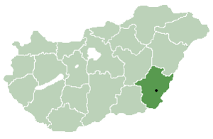
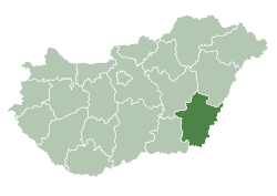
Location of Békés County in Hungary
Geography
It covers an area of 63.99 km² and has a population of 2650 people (2015).[1]
gollark: Sorry, network.
gollark: I suppose so.
gollark: Also all the rest of today.
gollark: As ever I *am* available later today.
gollark: <@!747067747569106974>
References
- Gazetteer of Hungary, 1 January 2015. Hungarian Central Statistical Office. 3 September 2015
| City with county rights |
|   |
|---|---|---|
| Towns | ||
| Large villages | ||
| Villages |
| |
| Other topics |
| |
This article is issued from Wikipedia. The text is licensed under Creative Commons - Attribution - Sharealike. Additional terms may apply for the media files.