Kreuzspitze (Ammergau Alps)
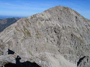
The Kreuzspitze (2,185 m) is the highest mountain in the Bavarian section of the Ammergau Alps and is the 21st highest mountain in Germany.
| Kreuzspitze | |
|---|---|
 The Kreuzspitze from the South | |
| Highest point | |
| Elevation | 2,185 m (7,169 ft) above sea level |
| Prominence | 1,182 m (3,878 ft) [1] |
| Isolation | 10.5 km |
| Coordinates | 47°31′35″N 10°55′07″E |
| Geography | |
| Parent range | Ammergau Alps |
| Geology | |
| Age of rock | Triassic |
| Mountain type | plattenkalk in the summit area, otherwise main dolomite[2] |
| Climbing | |
| Easiest route | State border – Hochgrießkar – Kreuzspitze |
The mountain is located southeast of the Ammer Saddle. The easiest route to the summit is along the normal path from the north through the Hochgrieß Cirque (Hochgrießkar). A more scenic and varied route, however, is over the Kreuzspitzl to the south and then along the scenic ridge (UIAA climbing grade I to II) to the main peak. The mountain also offers a challenging ski tour through the Hochgrieß Cirque.[3]
The surrounding peaks of Frieder, Geierköpfe and Schellschlicht are also popular tour destinations.
References
- "Kreuzspitze - peakbagger". peakbagger.com. Retrieved 20 March 2015.
- Geologische Karte von Bayern mit Erläuterungen (1:500,000). Bayerisches Geologisches Landesamt, 1998.
- Routen description of the ski tour
Sources
- Dieter Seibert: AVF Allgäuer Alpen und Ammergauer Alpen, Rother Verlag Munich, 2004, ISBN 3-7633-1126-2
This article is issued from Wikipedia. The text is licensed under Creative Commons - Attribution - Sharealike. Additional terms may apply for the media files.
