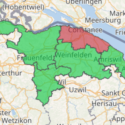
Kreuzlingen District
Kreuzlingen District is one of the five districts of the canton of Thurgau in Switzerland. It has a population of 48,345 (as of 31 December 2018).[1] Its capital is the city of Kreuzlingen.
Kreuzlingen District Bezirk Kreuzlingen | |
|---|---|
District | |
| |
| Country | |
| Canton | |
| Capital | Kreuzlingen |
| Area | |
| • Total | 129.0 km2 (49.8 sq mi) |
| Population (2018) | |
| • Total | 48,345 |
| • Density | 370/km2 (970/sq mi) |
| Time zone | UTC+1 (CET) |
| • Summer (DST) | UTC+2 (CEST) |
| Municipalities | 14 |
The district contains the following municipalities:
| Coat of arms | Municipality | Population (31 December 2018)[1] |
Area km²[2] |
|---|---|---|---|
| Altnau | 2,244 | 6.7 | |
| Bottighofen | 2,226 | 2.4 | |
| Ermatingen | 3,455 | 10.4 | |
| Gottlieben | 340 | 0.4 | |
| Güttingen | 1,591 | 9.5 | |
| Kemmental | 2,545 | 28.4 | |
| Kreuzlingen | 22,004 | 11.5 | |
| Langrickenbach | 1,291 | 10.9 | |
| Lengwil | 1,734 | 8.9 | |
| Münsterlingen | 3,476 | 5.4 | |
| Raperswilen | 415 | 7.7 | |
| Salenstein | 1,323 | 6.6 | |
| Tägerwilen | 4,642 | 11.6 | |
| Wäldi | 1,059 | 12.3 | |
| Total (14) | 48,345 | 129.0 |
References
- Swiss Federal Statistical Office - STAT-TAB, online database – Ständige und nichtständige Wohnbevölkerung nach institutionellen Gliederungen, Geburtsort und Staatsangehörigkeit (in German) accessed 23 September 2019
- Swiss Federal Statistical Office-Land Use Statistics 2009 data (in German) accessed 25 March 2010
This article is issued from Wikipedia. The text is licensed under Creative Commons - Attribution - Sharealike. Additional terms may apply for the media files.