Koyra Union
Koyra Union (Bengali: কয়রা ইউনিয়ন) is one of the seven union councils under Koyra Upazila of Khulna District in the Khulna Division of southern region Bangladesh.[1][2]
Koyra Union কয়রা ইউনিয়ন | |
|---|---|
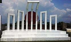
 Shahid Minar of Koyra Upazila | |
 Koyra Union Location of Koyra Union in Bangladesh | |
| Coordinates: 22°20.5′N 89°18′E | |
| Country | Bangladesh |
| Division | Khulna Division |
| District | Khulna District |
| Upazila | Koyra Upazila |
| Government | |
| • Type | Union Council |
| Time zone | UTC+6 (BST) |
| Postal code | 9290 |
| Website | Official Website of Koyra Union |
Geography
Koyra Union has an area of 8250 acres (20.5 sq km).[3] Koyra Union is located at the Koyra Sadar of Koyra Upazila. It shares borders with Moharajpur Union to the north, Dakkhin Bedkasi and Kapotaksha River located In the south, To the east Shakbaria River and Sundarbans, to the west are the Kapotaksha River and Shamnagar upazila of Satkhira district.[4]
Educational institutions
gollark: Humans are BAD AT RANDOMNESS.
gollark: You can't really verify that they're not fiddling with it
gollark: FIXED. CEASE COMPLAINT. FIXED.
gollark: Thus, unconscious bias fixed?
gollark: See, people complain about unconscious bias a lot. So I thought "well, ignoring all the issues about consciousness in software or whatever, surely it would be better if it didn't have this". And the "conscious" well-documented bias outweighs any possible *un*conscious bias loads!
References
- "ইউনিয়ন সমূহ - কয়রা উপজেলা". Koyra.khulna.gov.bd. Retrieved 2020-01-15.
- "বাংলাদেশের ইউনিয়ন সমূহ - কয়রা উপজেলা". oldweb.lged.gov.bd. Retrieved 2020-01-15.
- "কয়রা উপজেলা". oldweb.lged.gov.bd. Retrieved 2020-01-15.
- "বাংলাদেশ পরিসংখ্যান ব্যুরো (BBS)- তথ্য বাতায়ন". bbs.gov.bd. Retrieved 2020-01-15.
External links
This article is issued from Wikipedia. The text is licensed under Creative Commons - Attribution - Sharealike. Additional terms may apply for the media files.