Kotel Gap
Kotel Gap (Kotelska Sedlovina \'ko-tel-ska se-dlo-vi-'na\) is a saddle of elevation 660 m extending 1 km between Serdica Peak and Silistra Knoll in Levski Ridge, Tangra Mountains on Livingston Island in the South Shetland Islands, Antarctica. The saddle is part of the divide between the glacial catchments of Macy Glacier to the north and Boyana Glacier to the south. It was named after the Bulgarian town of Kotel.

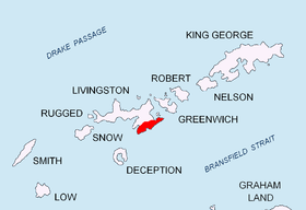
Location of Tangra Mountains on Livingston Island in the South Shetland Islands.

Kotel Gap from Bransfield Strait.

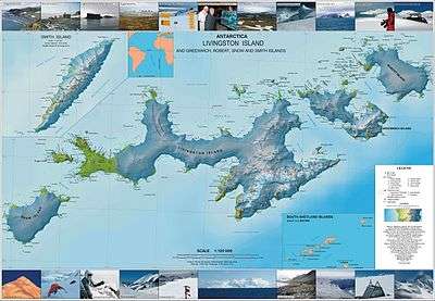
Topographic map of Livingston Island, Greenwich, Robert, Snow and Smith Islands.
Location
The midpoint is located at 62°41′23″S 60°04′53″W.
Maps
- L.L. Ivanov et al. Antarctica: Livingston Island and Greenwich Island, South Shetland Islands. Scale 1:100000 topographic map. Sofia: Antarctic Place-names Commission of Bulgaria, 2005.
- L.L. Ivanov. Antarctica: Livingston Island and Greenwich, Robert, Snow and Smith Islands. Scale 1:120000 topographic map. Troyan: Manfred Wörner Foundation, 2009.
gollark: You know, for purposes.
gollark: <@!330678593904443393> What if I write another entry for you?!
gollark: Hmm.
gollark: Okay, so to make you wrong I just need to somehow impersonate you to HelloBoi.
gollark: Your sample size is three (3).
References
- Kotel Gap. SCAR [Composite Antarctic Gazetteer]]
- Bulgarian Antarctic Gazetteer. Antarctic Place-names Commission. (details in Bulgarian, basic data in English)
External links
- Kotel Gap. Copernix satellite image
This article includes information from the Antarctic Place-names Commission of Bulgaria which is used with permission.
This article is issued from Wikipedia. The text is licensed under Creative Commons - Attribution - Sharealike. Additional terms may apply for the media files.