Kosrae International Airport
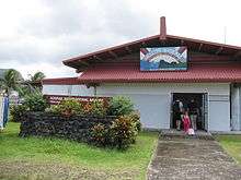
Kosrae International Airport (IATA: KSA, ICAO: PTSA, FAA LID: TTK) is an airport serving Kosrae, the easternmost state of the Federated States of Micronesia. It is located on an artificial island within the fringing reef about 150 meters from the coast and is connected to the main island by a causeway.
Kosrae International Airport | |||||||||||
|---|---|---|---|---|---|---|---|---|---|---|---|
 | |||||||||||
| Summary | |||||||||||
| Airport type | Public | ||||||||||
| Location | Okat | ||||||||||
| Elevation AMSL | 11 ft / 3 m | ||||||||||
| Coordinates | 05°21′25″N 162°57′30″E | ||||||||||
| Map | |||||||||||
 Kosrae International Airport | |||||||||||
| Runways | |||||||||||
| |||||||||||
The airport has been continuously served by the United Airlines (formerly Continental Micronesia) Island Hopper service between Guam and Honolulu, which stops twice weekly at Kosrae in each direction. Kosrae is three jogs from both Guam and Honolulu. As of June 2015, Nauru Airlines stops at Kosrae once a week in each direction between Nauru and Chuuk.
Airlines and destinations
| Airlines | Destinations |
|---|---|
| Caroline Islands Air | Charter: Pohnpei |
| United Airlines | Chuuk, Guam, Honolulu, Kwajalein, Majuro, Pohnpei |
gollark: Well, you can:- obtain some sort of vehicle/device/apparatus allowing transport of food in bulk- store high-density food or redesignate space appropriately for food storage- obtain nonperishable/slowly perishable foods or a "refrigerator"
gollark: > In software development, when we fix a problem, it's fixed for good and we will likely never deal with the same problem again.HAHAHAHAHAHÅHAHAHAHAHÆÆĦÆĦÆĦÆĦ
gollark: Is this for classified apioproject 1249H?
gollark: Wait, why are you writing a memory allocator?
gollark: Linked list bad, mostly.
References
External links
- Kosrae Visitors Center: Jewel of Micronesia
- Airport information for PTSA at World Aero Data. Data current as of October 2006.
- AirNav.com: FAA information for PTSA
- CrusingAltitude.com's photo essay of KSA
- Photos of Kosrae
This article is issued from Wikipedia. The text is licensed under Creative Commons - Attribution - Sharealike. Additional terms may apply for the media files.