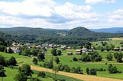
Koroška Vas, Novo Mesto
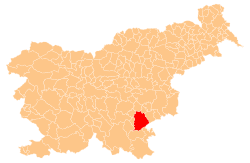
Koroška Vas (pronounced [kɔˈɾoːʃka ˈʋaːs]; Slovene: Koroška vas) is a settlement in the hills south of Novo Mesto in southeastern Slovenia. The area is part of the traditional region of Lower Carniola and is now included in the Southeast Slovenia Statistical Region.[2]
Koroška Vas | |
|---|---|
 | |
 Koroška Vas Location in Slovenia | |
| Coordinates: 45°44′45.26″N 15°11′41.83″E | |
| Country | |
| Traditional region | Lower Carniola |
| Statistical region | Southeast Slovenia |
| Municipality | Novo Mesto |
| Area | |
| • Total | 2.92 km2 (1.13 sq mi) |
| Elevation | 281.6 m (923.9 ft) |
| Population (2002) | |
| • Total | 194 |
| [1] | |
Name
The name Koroška vas literally means 'Carinthian village'. It was attested in written sources in 1485 as Koroschndorf vnder Meichaw. The name refers to a settlement that was colonized by arrivals from Carinthia in the Middle Ages. See also Koroška Vas na Pohorju and Koroška Bela for similar names outside Carinthia.[3]
gollark: That does not mean what you seem to think it means.
gollark: "Dimensions"?
gollark: Whaaaa?
gollark: Can you prove the existence of multiverses?
gollark: Instead of creating the universes, maybe just simulate some with intelligent life?
References
- Statistical Office of the Republic of Slovenia
- Novo Mesto municipal site Archived 2009-06-09 at the Wayback Machine
- Snoj, Marko (2009). Etimološki slovar slovenskih zemljepisnih imen. Ljubljana: Modrijan. pp. 201–202.
External links

- Koroška Vas on Geopedia
This article is issued from Wikipedia. The text is licensed under Creative Commons - Attribution - Sharealike. Additional terms may apply for the media files.
