Korfantów
Korfantów [kɔrˈfantuf] (German: Friedland in Oberschlesien), formerly known in Polish as Fryląd, is a town in the Opole Voivodeship of southwestern Poland, with 1,808 inhabitants (2019). In 1946 the town was renamed in honour of politician and activist Wojciech Korfanty, however, the previous name Fryląd is still in use.
Korfantów | |
|---|---|
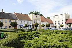
 Market Square | |
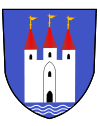
 Flag  Coat of arms | |
 Korfantów | |
| Coordinates: 50°30′N 17°36′E | |
| Country | |
| Voivodeship | Opole |
| County | Nysa |
| Gmina | Korfantów |
| Government | |
| • Mayor | Janusz Wójcik |
| Area | |
| • Total | 10.22 km2 (3.95 sq mi) |
| Elevation | 203 m (666 ft) |
| Population (2019-06-30[1]) | |
| • Total | 1,808 |
| • Density | 180/km2 (460/sq mi) |
| Time zone | UTC+1 (CET) |
| • Summer (DST) | UTC+2 (CEST) |
| Postal code | 48-317 |
| Website | Official website |
Geography
Korfantów is located in the Niemodlin Plain (Równina Niemodlińska), in the historical region of Silesia. The total area inside the town's boundary is 10,23 km².[2]
Etymology
The former name for the settlement was Hurtlanth or Hurthland. Other documents relate to the town as: Fredland, Fredelant, Fredlandt, Fridland, Freijland, Stadt Friedland and Friedland. Over time, the locality's Polish name was remodelled to its German counterpart, and was namely referred to as: Ferląd, Ferlondt, Frydląd, Fyrląd, and officially as Fryląd. After World War II, due to the town's German etymology, the settlement was renamed after Wojciech Korfanty.[3]
History

Until 1532 the area was in the possession of Polish princes of the Silesian Piast Dynasty. Simultaneously, an influx of German settlers caused the town to develop; it became the property of wealthy German and Silesian nobles. In 1632, the Swedes plundered Friedland and surrounding villages during the Thirty Years' War. Over the next decades the town also suffered due to plagues and fires. At that time, Friedland was part of the Kingdom of Bohemia within the Habsburg Monarchy. In 1645 it returned to Poland under the House of Vasa, and in 1666 it fell to Bohemia again, however, it was ceded to Prussia after Frederick II the Great emerged victorious in the mid-18th century Silesian Wars. In the 19th century, despite Prussian and German rule, Catholic services were still held in Polish alongside German.[4] It was part of Germany from 1871 until the end of World War II in 1945, when, under the Potsdam Agreement, it was reassigned to Poland.[5] During World War II, the Polenlager 85 Nazi German concentration camp for Poles was based in the town in 1942–1943.[5] A mass grave of its prisoners is located at the local parish cemetery.[5]
Economy

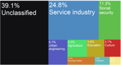
In the interwar period, there were 152 registered businesses in Korfantów, namely: services, trade and food production. After World War II, the town lost its former importance as the agricultural centre in the Nysa County. This was largely the effect of war losses, requisitioning, plunder and the Red Army's war commissar's rule over the locality in 1945, as well as poor political decisions. Later, the regime of the Polish People's Republic caused much impoverishment and financial instability, therefore, it was not until the reintroduction of the free market in 1989 that economic growth began to return. As of 2015, 52% of the Gmina Korfantów populace lives off the agricultural sector.[6][7]
Notable people
- Emelie Mayer (1812–1883), composer
- Carl Friedrich von Pückler-Burghauss (1886–1945), Waffen SS General
- Maria Kornek (born 1960), Polish Olympic field hockey player
- Lucyna Siejka (born 1962), Polish Olympic field hockey player
Twin towns – sister cities
See twin towns of Gmina Korfantów.
References
- "Population. Size and structure and vital statistics in Poland by territorial divison in 2019. As of 30th June". stat.gov.pl. Statistics Poland. 2019-10-15. Retrieved 2020-02-14.
- www.ideo.pl, ideo -. "Powierzchnia i ludność w przekroju terytorialnym w 2013 r." stat.gov.pl (in Polish). Retrieved 1 February 2017.
- "Zabytki - Urząd Miejski w Korfantowie". www.korfantow.pl. Retrieved 1 February 2017.
- Słownik geograficzny Królestwa Polskiego i innych krajów słowiańskich, Tom II, Warszawa, 1881, p. 425 (in Polish)
- "Kronika miasta Korfantów - I połowa XX wieku". Urząd Miejski w Korfantowie (in Polish). Retrieved 20 March 2020.
- "Korfantów". www.polskawliczbach.pl (in Polish). Retrieved 1 February 2017.
- "Komunikaty dla rolników - Urząd Miejski w Korfantowie". www.korfantow.pl. Retrieved 1 February 2017.
External links
- Jewish Community in Korfantów on Virtual Shtetl
| Wikimedia Commons has media related to Korfantów. |