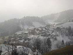
Koreno nad Horjulom
Koreno nad Horjulom (pronounced [kɔˈɾeːnɔ nat xɔˈrjuːlɔm]) is a settlement in the hills north of Horjul in the Inner Carniola region of Slovenia.[2]
Koreno nad Horjulom | |
|---|---|
 | |
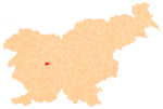
 Koreno nad Horjulom Location in Slovenia | |
| Coordinates: 46°1′58.06″N 14°17′18.42″E | |
| Country | |
| Traditional region | Inner Carniola |
| Statistical region | Central Slovenia |
| Municipality | Horjul |
| Area | |
| • Total | 4.41 km2 (1.70 sq mi) |
| Elevation | 662.3 m (2,172.9 ft) |
| Population (2002) | |
| • Total | 110 |
| [1] | |
Name
The name of the settlement was changed from Koreno to Koreno nad Horjulom in 1953.[3]
Church
.jpg)
Sts. Hermagoras and Fortunatus Church
The local church in the settlement is dedicated to Saints Hermagoras and Fortunatus and belongs to the Parish of Horjul.[4]
gollark: I should totally implement this.
gollark: Good, good.
gollark: <@!309787486278909952> OPINE on my new ISA.
gollark: Fine, it also has SELECT and MINGLE, because bee you.
gollark: Good, I'll look those up.
References
- Statistical Office of the Republic of Slovenia
- Horjul municipal site
- Spremembe naselij 1948–95. 1996. Database. Ljubljana: Geografski inštitut ZRC SAZU, DZS.
- Družina RC in Slovenia journal site
External links
| Settlements | Administrative centre: Horjul
|  |
|---|---|---|
| Landmarks |
| |
| Notable people |
| |
This article is issued from Wikipedia. The text is licensed under Creative Commons - Attribution - Sharealike. Additional terms may apply for the media files.