Kop Nück
Kop Nück, also called Am Kopnück, is a small settlement, which belongs to the town of Bad Münstereifel in the district of Euskirchen in the German state of North Rhine-Westphalia.
Kop Nück | |
|---|---|
hamlet of Bad Münstereifel | |
Location of Kop Nück 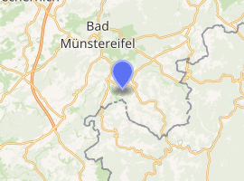
| |
 Kop Nück  Kop Nück | |
| Coordinates: 50°30′02″N 6°48′03″E | |
| Country | Germany |
| State | North Rhine-Westphalia |
| Municipality | Bad Münstereifel |
| Elevation | 457 m (1,499 ft) |
| Time zone | CET/CEST (UTC+1/+2) |
| Postal codes | 53902 |
| Dialling codes | 02253 |
Location
Kop Nück lies 1.3 km south-southwest of Mahlberg and 2 km (both as the crow flies) southeast of Schönau, which are also part of Bad Münstereifel's borough. It is surrounded by the Schönau Forest (Schönauer Wald) and the hill of Kopnück (514.4 m) to the west. Roughly to the north of this hamlet, which lies at elevations of 440 to 460 m above sea level (NHN),[1] runs the Landesstraße 165 in the valley of the Krumesbach from Esch, through Mahlberg to Schönau. To the south is the state border with Rhineland-Palatinate.
gollark: I could post about other stuff, but my programming projects lately have been somewhat suspended?
gollark: It's not me. It's a rapidly self perpetuating apiomemetic feedback loop.
gollark: Sustainable month use is a very important issue.
gollark: ↑
gollark: In Bees Month you will celebrate the abstract concept of bees and not bees themselves.
References
- Map services of the Federal Agency for Nature Conservation
External links
Borough of Bad Münstereifel | ||
|---|---|---|
| ||
This article is issued from Wikipedia. The text is licensed under Creative Commons - Attribution - Sharealike. Additional terms may apply for the media files.