Kolokita Cove
Kolokita Cove (Bulgarian: залив Колокита, ‘Zaliv Kolokita’ \'za-liv ko-lo-'ki-ta\) is the 2.7 km wide embayment indenting for 1.55 km the northwest coast of Alexander Island in Antarctica. It is entered east of the coastal point formed by Hopkins Ridge and west of Piyanets Ridge, and has its head fed by Coulter Glacier. The feature is named after Kolokita Point on the Bulgarian Black Sea Coast.
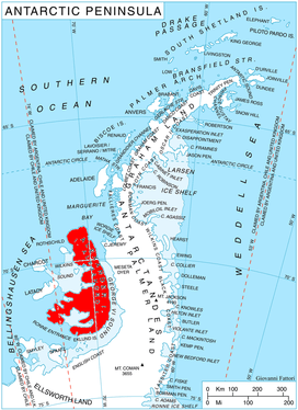
Location of Alexander Island in the Antarctic Peninsula region
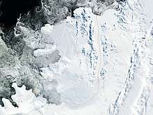
Satellite image of Alexander Island
Location
Kolokita Cove is centered at 69°21′50″S 71°49′00″W.
Maps
- British Antarctic Territory. Scale 1:200000 topographic map. DOS 610 – W 69 70. Tolworth, UK, 1971
- Antarctic Digital Database (ADD). Scale 1:250000 topographic map of Antarctica. Scientific Committee on Antarctic Research (SCAR). Since 1993, regularly upgraded and updated
gollark: Rust will be allowed iff Rust is allowed.
gollark: JSON is defined as on here (https://www.json.org/json-en.html) except that input strings are constrained to ASCII, for purposes (Unicode escapes are permitted).
gollark: Okay, the challenge is to validate JSON, i.e. to take a string and return a boolean indicating whether it is a valid JSON value or not.
gollark: I can define a subset of JSON.
gollark: I suppose we can drop string stuff, yes.
References
- Bulgarian Antarctic Gazetteer. Antarctic Place-names Commission. (details in Bulgarian, basic data in English)
- Kolokita Cove. SCAR Composite Gazetteer of Antarctica
External links
- Kolokita Cove. Copernix satellite image
This article includes information from the Antarctic Place-names Commission of Bulgaria which is used with permission.
This article is issued from Wikipedia. The text is licensed under Creative Commons - Attribution - Sharealike. Additional terms may apply for the media files.