Klátova Nová Ves
Klátova Nová Ves (German Stockneudorf, Hungarian Ujfalutőkés or Tőkésújfalu) is a village and municipality in Partizánske District in the Trenčín Region of western Slovakia. It was named until 1927 Klatnovejsa.
Klátova Nová Ves | |
|---|---|
Municipality | |
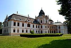
 Haupt-Stummer mansion | |
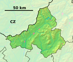
 Klátova Nová Ves Location of Klátova Nová Ves in the Trenčín Region  Klátova Nová Ves Klátova Nová Ves (Slovakia) | |
| Coordinates: 48°34′N 18°18′E | |
| Country | Slovakia |
| Region | Trenčín |
| District | Partizánske |
| First mentioned | 1310 |
| Area | |
| • Total | 35.038 km2 (13.528 sq mi) |
| Elevation | 199 m (653 ft) |
| Population (2018-12-31[1]) | |
| • Total | 1,570 |
| • Density | 45/km2 (120/sq mi) |
| Postal code | 958 44 |
| Area code(s) | 421-38 |
| Car plate | PE |
| Website | www.klatovanovaves.sk |
History
In historical records the village was first mentioned in 1310. It belonged to the Kingdom of Hungary until 1918.

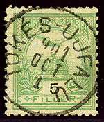
Hungarian stamp cancelled Tőkés-Ujfalu in 1901
Geography
The municipality lies at an altitude of 199 metres and covers an area of 35.038 km². It has a population of about 1570 people.
Genealogical resources
The records for genealogical research are available at the state archive "Statny Archiv in Nitra, Slovakia"
- Roman Catholic church records (births/marriages/deaths): 1726-1901 (parish A)
- Lutheran church records (births/marriages/deaths): 1708-1895 (parish B)
gollark: A moderately old smartphone would handily outperform this.
gollark: Worrying.
gollark: Just buy one of those terrible x5-Z8350 boards.
gollark: I think P3s have it?
gollark: Out of order execution.
External links
![]()
References
- "Population and migration". Statistical Office of the Slovak Republic. Retrieved 2019-04-16.
This article is issued from Wikipedia. The text is licensed under Creative Commons - Attribution - Sharealike. Additional terms may apply for the media files.