Kirkandrews-on-Esk
Kirkandrews (also known as Kirkandrews-on-Esk[1] distinguishing it from Kirkandrews-on-Eden), is a civil parish in City of Carlisle district, Cumbria, England. At the 2011 census it had a population of 493.[2]
| Kirkandrews | |
|---|---|
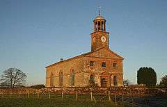 The grade II* listed St Andrew's Church in the parish | |
 Kirkandrews Location within Cumbria | |
| Area | 43.8536 km2 (16.9320 sq mi) |
| Population | 493 (2011) |
| • Density | 11/km2 (28/sq mi) |
| Civil parish |
|
| District | |
| Shire county | |
| Region | |
| Country | England |
| Sovereign state | United Kingdom |
| Post town | Carlisle |
| Postcode district | CA6 |
The parish is bordered to the west and north by Dumfries and Galloway, Scotland; to the north east by Nicholforest, and to the south by Arthuret.[3] The area of the parish is 4,385 ha (16.93 sq mi; 43.85 km2).[2]
There is a parish council, the lowest tier of local government.[4][5]
Listed buildings
As of 2017 there are 13 listed buildings in the parish, of which three are at grade II* and the others at grade II.
gollark: Wow. This is... quite something.
gollark: <@202992030685724675> It may be more useful to actually have working hardware before mocking up a UI.
gollark: I don't know.
gollark: Implying of course that you actually do this.
gollark: Are you using some preexisting board or what?
References
- "Kirkandrews on Esk Parish Council". sites.google.com. Retrieved 6 August 2020.
- UK Census (2011). "Local Area Report – Kirkandrews Parish (E04002464)". Nomis. Office for National Statistics.
- "Information on: Kirkandrews (Parish)". Neighbourhood Statistics. Office of National Statistics. Retrieved 17 April 2017.
- "Kirkandrews-on-Esk Parish Council". Cumbria County Council. Retrieved 6 August 2020.
- "Kirkandrews on Esk Parish Council". Carlisle City Council. Retrieved 17 April 2017.
External links
- "Kirkandrews upon Esk through time". A Vision of Britain Through Time. Retrieved 17 April 2017.
This article is issued from Wikipedia. The text is licensed under Creative Commons - Attribution - Sharealike. Additional terms may apply for the media files.