Kilmore, Indiana
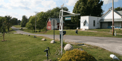
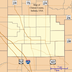
Kilmore is an unincorporated community in Union Township, Clinton County, Indiana. The town was laid out in 1854 by Abner C. Pence and for twenty years was known as Penceville, but after it became a station on the Vandalia Railroad in 1870 the company changed its name to Kilmore after the nearby creek (which was named for settler John Killmore).[3][4]
Kilmore | |
|---|---|
 | |
 Kilmore | |
| Coordinates: 40°20′55″N 86°30′20″W | |
| Country | United States |
| State | Indiana |
| County | Clinton |
| Township | Union |
| Founded | 1854 |
| Elevation | 833 ft (254 m) |
| ZIP code | 46041 |
| FIPS code | 18-39726[1] |
| GNIS feature ID | 437301[2] |
A post office was established at Kilmore in 1872, and remained in operation until it was discontinued in 1903.[5]
Geography
Kilmore is located at 40°20′55″N 86°30′20″W.
gollark: The cycle frequency should increase as we approach the ides.
gollark: I see the memetics worked as designed then.
gollark: How is it "not transparency"? Are you just trying to limit information about staff things spreading? That is basically the opposite of transparency.
gollark: I didn't mean me personally either.
gollark: I *also* think your assumptions of malice are wrong, but thing.
References
- "U.S. Census website". United States Census Bureau. Retrieved 2008-01-31.
- "Kilmore, Indiana". Geographic Names Information System. United States Geological Survey. Retrieved 2009-10-17.
- Claybaugh, Joseph (1913). History of Clinton County, Indiana. Indianapolis: A. W. Bowen & Company. pp. 32.
- Claybaugh, Joseph (1913). "Union Township". History of Clinton County, Indiana. Indianapolis: A. W. Bowen & Company.
- "Clinton County". Jim Forte Postal History. Retrieved 30 August 2014.
This article is issued from Wikipedia. The text is licensed under Creative Commons - Attribution - Sharealike. Additional terms may apply for the media files.