Kiefersfelden
Kiefersfelden is a municipality with about 7000 inhabitants located in the district of Rosenheim in Bavaria in Germany on the border with Tyrol, Austria.
Kiefersfelden | |
|---|---|
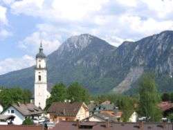 Church of the Holy Cross in Kiefersfelden with Kaiser Mountains in the background | |
 Coat of arms | |
Location of Kiefersfelden within Rosenheim district 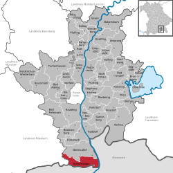 | |
 Kiefersfelden  Kiefersfelden | |
| Coordinates: 47°37′N 12°11′E | |
| Country | Germany |
| State | Bavaria |
| Admin. region | Oberbayern |
| District | Rosenheim |
| Government | |
| • Mayor | Hajo Gruber (UW) |
| Area | |
| • Total | 36.72 km2 (14.18 sq mi) |
| Elevation | 490 m (1,610 ft) |
| Population (2018-12-31)[1] | |
| • Total | 6,821 |
| • Density | 190/km2 (480/sq mi) |
| Time zone | CET/CEST (UTC+1/+2) |
| Postal codes | 83088 |
| Dialling codes | 08033 |
| Vehicle registration | RO |
| Website | www.kiefersfelden.de |
Geography
Geographical location
Kiefersfelden is located in the foothills of the Alps, in the Bavarian part of the Unterinntal, at an altitude of about 484 m (1,587.93 ft) ASL.
The local rivers are the Inn and the Kieferbach.
Nearby places
- Bayrischzell
- Ebbs in Tyrol
- Kufstein in Tyrol
- Oberaudorf
- Thiersee in Tyrol
gollark: But why?
gollark: I have an ancient iLO 3 thing.
gollark: Who added chat features to a management console?!
gollark: Also giant power bills.
gollark: Point antenna at them, watch as they constantly complain, tell them it wasn't turned on?
References
- "Fortschreibung des Bevölkerungsstandes". Bayerisches Landesamt für Statistik und Datenverarbeitung (in German). July 2019.
| Authority control |
|
|---|
This article is issued from Wikipedia. The text is licensed under Creative Commons - Attribution - Sharealike. Additional terms may apply for the media files.