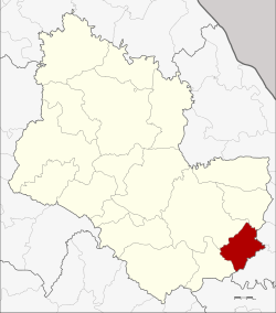
Khok Si Suphan District
Khok Si Suphan (Thai: โคกศรีสุพรรณ, pronounced [kʰôːk sǐː sù.pʰān]) is a district (amphoe) of Sakon Nakhon Province, northeast Thailand.
Khok Si Suphan โคกศรีสุพรรณ | |
|---|---|
 District location in Sakon Nakhon Province | |
| Coordinates: 17°2′37″N 104°16′24″E | |
| Country | Thailand |
| Province | Sakon Nakhon |
| Seat | Tong Khop |
| Area | |
| • Total | 212.0 km2 (81.9 sq mi) |
| Population (2005) | |
| • Total | 33,717 |
| • Density | 159.0/km2 (412/sq mi) |
| Time zone | UTC+7 (ICT) |
| Postal code | 47280 |
| Geocode | 4715 |
History
The minor district (king amphoe) was created on 5 May 1981, when the three tambons Tong Khop, Lao Phon Kho, and Dan Muang Kham were split off from Mueang Sakon Nakhon District.[1] It was upgraded to a full district on 9 May 1992.[2]
Geography
Neighbouring districts are (from the south clockwise) Tao Ngoi, Mueang Sakon Nakhon and Phon Na Kaeo of Sakon Nakhon Province, Wang Yang and Na Kae of Nakhon Phanom Province.
Demographics
The people of Khok Si Suphan are predominantly of Phu Thai and Nyaw ethnicity.
Administration
The district is divided into four sub-districts (tambons), which are further subdivided into 52 villages (mubans). There are no municipal (thesaban) areas, and a further four tambon administrative organizations.
| No. | Name | Thai name | Villages | Pop. | |
|---|---|---|---|---|---|
| 1. | Tong Khop | ตองโขบ | 17 | 12,273 | |
| 2. | Lao Phon Kho | เหล่าโพนค้อ | 11 | 5,769 | |
| 3. | Dan Muang Kham | ด่านม่วงคำ | 11 | 7,029 | |
| 4. | Maet Na Thom | แมดนาท่ม | 13 | 8,646 |
References
- ประกาศกระทรวงมหาดไทย เรื่อง แบ่งท้องที่อำเภอเมืองสกลนคร จังหวัดสกลนคร ตั้งเป็นกิ่งอำเภอโคกศรีสุพรรณ (PDF). Royal Gazette (in Thai). 98 (90 ง): 1731. June 9, 1991.
- พระราชกฤษฎีกาตั้งอำเภอสอยดาว อำเภอโพนสวรรค์ อำเภอบางขัน อำเภอหว้านใหญ่ อำเภอเมืองปาน อำเภอภูหลวง อำเภอโคกศรีสุพรรณ และอำเภอสำโรง พ.ศ. ๒๕๓๕ (PDF). Royal Gazette (in Thai). 109 (45 ก): 27–29. April 9, 1992.