Khoda Afarin Dam
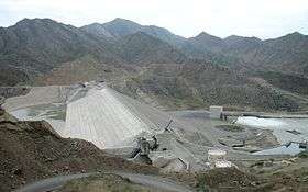
Khoda Afarin Dam (also spelled as Khodaafarin Dam or Hudafarin Dam) is an earth-fill embankment dam on the Aras River straddling the international border between Iran and Azerbaijan. It is located 8 kilometres (5.0 mi) west of Khomarlu in East Azerbaijan Province, Iran and 14 kilometres (8.7 mi) southwest of Soltanlı in Jabrayil District, Azerbaijan, de facto controlled by the Nagorno-Karabakh (Artsakh) Republic since 1993. It is located 1 km (0.62 mi) upstream of the Khodaafarin Bridges.
| Khoda Afarin Dam | |
|---|---|
 | |
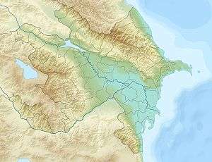
 Location of Khoda Afarin Dam in Azerbaijan | |
| Country | Iran/de facto: Nagorno-Karabakh Republic, de jure: Azerbaijan |
| Location | Khomarlu, East Azerbaijan Province/Soltanlı, de facto: Hadrut Province, de jure: Jabrayil Rayon |
| Coordinates | 39°9′35″N 46°56′05″E |
| Status | Operational |
| Construction began | 1999 |
| Opening date | 2008 |
| Owner(s) | East Azerbaijan Regional Water Authority |
| Dam and spillways | |
| Type of dam | Embankment, earth-fill |
| Impounds | Aras River |
| Height | 64 m (210 ft)[1] |
| Length | 400 m (1,300 ft)[2] |
| Reservoir | |
| Total capacity | 1,612×106 m3 (1,307,000 acre⋅ft) |
| Active capacity | 1,495×106 m3 (1,212,000 acre⋅ft)[3] |
| Power Station | |
| Installed capacity | 102 MW (137,000 hp) |
The purpose of the dam is hydroelectric power generation and irrigation. It was conceived as a joint project with the Soviet Union and both sides reached an agreement in October 1977. Designs were finalized in 1982, revised in the early 1990s and construction began in 1999.[3] According to Armenian media reports, Iran made a secret agreement with Armenia (which controls Nagorno-Karabakh) to complete the project.[4][5]
The dam was complete and began to impound water in 2008. It was inaugurated in 2010. The irrigation works are still underway.[6] During construction, several Bronze Age sites were discovered, including the grave of a Saka-Scythian warrior. The reservoir filling, or impoundment, was delayed in 2008 to accommodate excavations.[7][8] The dam's power plant has an installed capacity of 102 megawatts (137,000 hp) and is designed to irrigate 75,000 hectares (190,000 acres).[3][9]
References
- "Dams (>15 m) Under Construction in IRAN" (PDF). WRM. Retrieved 21 April 2012.
- "Construction operation of Khoda Afarin dam power plant was begun". Farab Co. Archived from the original on 29 July 2012. Retrieved 21 April 2012.
- "Reducing Transboundary Degradation of Kura-Aras River Basin" (PDF). National Report of Islamic Republic of Iran. National TDA-Islamic Republic of Iran. June 2006. p. 8. Retrieved 21 April 2012.
- Hakobyan, Tatul (11 March 2016). "Աստծո ջրամբարը. Խոդա Աֆարին [The Reservoir of God: Khoda Afarin]". civilnet.am (in Armenian).
- Hayrumyan, Naira (24 April 2016). "На что намекает Иран". lragir.am (in Russian).
Напомним, что Худаферинская ГЭС строится на реке Аракс, на границе Ирана и Карабаха, в соответствии с договором между Ираном и Арменией, заключенным в 2007 году.
- "Khdaafryn dam will irrigate 30 thousand hectares of land in East Azarbaijan" (in Persian). WNN. 20 April 2010. Retrieved 21 April 2012.
- "Archaeologists rush to save Bronze Age sites in northwestern Iran". Mehr News Agency (via Payvand Iran News). 2 December 2008. Retrieved 21 April 2012.
- "Grave of a Saka-Scythian Warrior Discovered at Khoda-Afarin Dam Reservoir". The Circle of Ancient Iranian Studies. 8 December 2008.
- http://www.farab.com/en/field_of_activities/prjList.asp?abv=H
