Khetri
Khetri Nagar is a town in Jhunjhunu district of Rajasthan in India. It is part of the Shekhawati region. Khetri is actually two towns, "Khetri Town" founded by Raja Khet Singhji Nirwan and "Khetri Nagar" which is about 10 km away from Khetri. Khetri Nagar, well known for its Copper Project, was built by and is under the control of Hindustan Copper Limited, a public sector undertaking under the Government of India. Khetri Nagar is also very well known with name of 'Copper'.
Khetri Khetri Khetdi | |
|---|---|
City | |
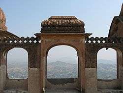
 Khetri fort | |
| Nickname(s): khetadi, Copper | |
 Khetri Location in Rajasthan, India | |
| Coordinates: 27.98°N 75.8°E | |
| Country | |
| State | Rajasthan |
| District | Jhunjhunu |
| Government | |
| • Body | Khetri Municipality and Gothra panchayat |
| Elevation | 484 m (1,588 ft) |
| Population (2011) | |
| • Total | 18,209(Khetri) + 16,933(Khetri Nagar) as per 2,011 census of india |
| Languages | |
| • Official | Hindi, Marwadi |
| Time zone | UTC+5:30 (IST) |
| PIN | 333504/333503 |
| Telephone code | 01593 |
| Vehicle registration | RJ53 |
Geography
Khetri is located at 27.98°N 75.8°E.[1] It has an average elevation of 484 metres (1587 feet). The name of the mountain in khetri is Bhopalgarh.
Demographics
As of 2001 India census,[2] Khetri had a population of 17,377. Males constitute 52% of the population and females 48%. Khetri has an average literacy rate of 67%, higher than the national average of 59.5%: male literacy is 77%, and female literacy is 56%. In Khetri, 15% of the population is under 6 years of age.
Khetri fort
Khetri fort was built in 1754 by the then Shekhawat raja, Bhopal Singh (Raja Shri Bhopal Singh Shekhawat Ji Saheb Bahadur).[3]
References
- Falling Rain Genomics, Inc - Khetri
- "Census of India 2001: Data from the 2001 Census, including cities, villages and towns (Provisional)". Census Commission of India. Archived from the original on 16 June 2004. Retrieved 1 November 2008.
- Dundlod, Harnath Singh (1970). The Sheikhawats and Their Lands. Jaipur: Raj Educational Printers. p. 122. OCLC 309570.
