Keramia
Keramia (Greek: Κεραμιά, Δήμος Κεραμιών) is a former municipality in the Chania regional unit, Crete, Greece. Since the 2011 local government reform it is part of the municipality Chania, of which it is a municipal unit.[2] The municipal unit has an area of 89.722 km2 (34.642 sq mi).[3] It is part of the former Kydonia Province.
Keramia Κεραμιά | |
|---|---|
 Keramia Location within the regional unit 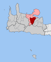 | |
| Coordinates: 35°25′N 24°2′E | |
| Country | Greece |
| Administrative region | Crete |
| Regional unit | Chania |
| Municipality | Chania |
| • Municipal unit | 89.7 km2 (34.6 sq mi) |
| Population (2011)[1] | |
| • Municipal unit | 678 |
| • Municipal unit density | 7.6/km2 (20/sq mi) |
| Time zone | UTC+2 (EET) |
| • Summer (DST) | UTC+3 (EEST) |
| Postal code | 731 00 |
| Area code(s) | 28210 |
| Vehicle registration | ΧΝ |
| Website | Keramia Website |
Keramia covers the high villages in the foothills of the White Mountains (Lefka Ori) to the south of the city of Chania. Though apparently close to Chania, the access to the villages of Keramia is by narrow winding hill roads, and hence the area is little developed or visited by tourists.
The seat of the municipality was Gerolakos. The municipal unit also includes Malaxa, Katochori, Kontopoula and Drakona.
See also
- List of communities of Chania
References
- "Απογραφή Πληθυσμού - Κατοικιών 2011. ΜΟΝΙΜΟΣ Πληθυσμός" (in Greek). Hellenic Statistical Authority.
- Kallikratis law Greece Ministry of Interior (in Greek)
- "Population & housing census 2001 (incl. area and average elevation)" (PDF) (in Greek). National Statistical Service of Greece. Archived from the original (PDF) on 2015-09-21.
External links
This article is issued from Wikipedia. The text is licensed under Creative Commons - Attribution - Sharealike. Additional terms may apply for the media files.