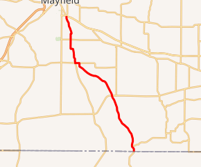
Kentucky Route 97
Kentucky Route 97 (KY 97) is a 18.262-mile-long (29.390 km) state highway in Graves County, Kentucky that runs from Tennessee State Route 69 (SR 69) and State Line Road West on the Kentucky-Tennessee state border southeast of Sedalia to KY 80, KY 121, and KY 121 Business just southeast of Mayfield.
| ||||
|---|---|---|---|---|

KY 97 highlighted in red | ||||
| Route information | ||||
| Maintained by KYTC | ||||
| Length | 18.262 mi[1] (29.390 km) | |||
| Major junctions | ||||
| South end | ||||
| North end | ||||
| Location | ||||
| Counties | Graves | |||
| Highway system | ||||
| ||||
Route description
KY 97 enters Kentucky on the Graves-Calloway County line and travels north for a few tenths of a mile before curving toward the northwest away from the Calloway County line. It continues to the northwest through rural sections of southeastern Graves County, passing through the unincorporated community of Bell City. Nearly 7 miles (11 km) from the Tennessee state line, KY 97 forms a junction with KY 94 and continues toward the northwest passing through Sedalia and forming a junction with KY 339/KY 381. After passing through Sedalia the route travels due north for nearly 5.5 miles (8.9 km) and terminates at a junction with KY 80/KY 121/KY 121 Business just south of Mayfield. The route remains two lanes for its entirety and passes through mostly rural sections of Graves County.
History
By 1937, KY 97 was a mostly unpaved road that terminated in the center of Mayfield. [2] By 1989, KY 97 ended at its current northern terminus at a junction with KY 121 just south of Mayfield.[3]
Major intersections
The entire route is in Graves County.
| Location | mi[1] | km | Destinations | Notes | |
|---|---|---|---|---|---|
| | 0.000 | 0.000 | Southern terminus; continues as SR 69 in Tennessee | ||
| | 0.688 | 1.107 | Western terminus of KY 1270 | ||
| | 2.725 | 4.385 | Northern terminus of KY 1485 | ||
| | 6.850 | 11.024 | |||
| | 12.268 | 19.743 | South end of KY 339 overlap | ||
| Sedalia | 12.676 | 20.400 | North end of KY 339 overlap; northern terminus of KY 381 overlap | ||
| | 15.536 | 25.003 | |||
| | 18.262 | 29.390 | Northern terminus; southern terminus of KY 121 Bus. | ||
| 1.000 mi = 1.609 km; 1.000 km = 0.621 mi | |||||
References
- "Official DMI Route Log". Kentucky Transportation Cabinet. Retrieved 30 June 2014.
- Graves County (PDF) (Map) (1937 ed.). 1 inch:125000 feet. Cartography by State-wide Highway Planning Survey. Kentucky State Highway Department. 1937. Retrieved July 27, 2014.
- Graves County (PDF) (Map) (1989 ed.). 1 inch:125000 feet. Cartography by State-wide Highway Planning Survey. Kentucky State Highway Department. 1989. Retrieved July 27, 2014.
