Kentucky Route 30
Kentucky Route 30 (KY 30) is an east–west state highway in Kentucky managed by the Kentucky Transportation Cabinet.
| ||||
|---|---|---|---|---|
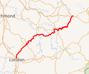
KY 30 highlighted in red | ||||
| Route information | ||||
| Maintained by KYTC | ||||
| Length | 102.023 mi[1] (164.190 km) | |||
| Major junctions | ||||
| West end | ||||
| ||||
| East end | ||||
| Location | ||||
| Counties | Laurel, Jackson, Owsley, Breathitt, Magoffin | |||
| Highway system | ||||
| ||||

It goes through Laurel, Jackson, Owsley, Breathitt, Magoffin Counties.
Route description
KY 30 begins at an intersection with the Hal Rogers Parkway in London, and goes north as a divided highway until it becomes an undivided two-lane highway about a mile up the road. The road is a recently constructed standard highway with 11ft wide lanes and shoulders on both sides of the road, with a speed limit of 55mph. The road continues through Greenmount into Jackson County. The road then goes through the hilly terrain of Jackson County, and runs past Annville and reaches US 421 at Tyner. At this point, the road is no longer a standard highway and runs as a concurrency to the northern part of Tyner, where it goes east towards Mummie. The road runs a very curvy route and reaches Owsley County where it continues to be curvy until it reaches another newly constructed standard highway at Travellers Rest, which continues past Vincent into Levi where the road intersects with KY 11. From here, the road follows a concurrent route with KY 11 into Booneville and heads west towards Breathitt County. From here, the road is curvy and goes into the town of Jackson where it then goes on another curvy route into Magoffin County where it meets its eastern terminus in Salyersville.
New alignment
Work has been done to improve the route of KY 30, to establish it as a corridor between London and the impoverished areas the road currently runs through. Beginning in 2003, KY 30 has been realigned on a ~7 mile segment between London and Greenmount, where construction stalled until 2010 when a ~15 mile segment was completed between Greenmount and Annville, where construction stalled again. In 2014, a ~5 mile segment was completed between Annville and Tyner. In a separate segment, a new ~7 mile alignment was constructed in Owsley County between Levi and Travellers Rest. It is estimated that the road will be completely connected as a new highway between Laurel, Jackson and Owsley Counties by 2022. Another development for the corridor may be under way for KY 11 between Levi and Beattyville to connect the realigned segment to another standard highway, to connect Lee, Powell, and Wolfe Counties to this new corridor that leads to London in Laurel County.
Major intersections
| County | Location | mi | km | Destinations | Notes |
|---|---|---|---|---|---|
| Laurel | London | 0.000 | 0.000 | ||
| | 2.785 | 4.482 | |||
| | 3.567 | 5.741 | Eastern terminus of KY 3094 | ||
| | 5.646 | 9.086 | Eastern terminus of KY 1394 | ||
| | 8.155 | 13.124 | West end of KY 578 overlap | ||
| | 8.246 | 13.271 | East end of KY 578 overlap | ||
| Jackson | Moores Creek | 11.663 | 18.770 | ||
| | 14.153 | 22.777 | |||
| Annville | 15.013 | 24.161 | |||
| | 15.715 | 25.291 | Southern terminus of KY 3629 | ||
| | 16.097 | 25.906 | West end of KY 3443 overlap | ||
| | 16.192 | 26.058 | East end of KY 3443 overlap | ||
| | 18.687 | 30.074 | West end of US 421 concurrency | ||
| | 18.839 | 30.318 | Western terminus of KY 1431 | ||
| Tyner | 18.972 | 30.532 | Eastern terminus of KY 3630; former routing of KY 30 | ||
| | 19.786 | 31.842 | East end of US 421 concurrency | ||
| | 22.047 | 35.481 | Eastern terminus of KY 1431 | ||
| Owsley | | 28.389 | 45.688 | West end of KY 1071 overlap | |
| | 28.768 | 46.298 | East end of KY 1071 overlap | ||
| | 31.560 | 50.791 | Western terminus of KY 846 | ||
| | 33.348 | 53.668 | Southern terminus of KY 847 | ||
| Vincent | 34.931 | 56.216 | Southern terminus of KY 399 | ||
| Travellers Rest | 38.962 | 62.703 | Northern terminus of KY 847 | ||
| | 39.303 | 63.252 | West end of KY 11 concurrency | ||
| | 39.892 | 64.200 | Western terminus of KY 3504 | ||
| Booneville | 41.532 | 66.839 | East end of KY 11 concurrency | ||
| 41.563 | 66.889 | Western terminus of KY 28 | |||
| | 42.610 | 68.574 | Northern terminus of KY 3347 | ||
| | 42.931 | 69.091 | Southern terminus of KY 3346 | ||
| | 43.204 | 69.530 | Southern terminus of KY 1411 | ||
| Lerose | 45.303 | 72.908 | Southern terminus of KY 708 | ||
| | 45.901 | 73.870 | Northern terminus of KY 2024 | ||
| Breathitt | | 51.460 | 82.817 | Southern terminus of KY 1202 | |
| | 53.429 | 85.986 | Northern terminus of KY 1114 | ||
| | 54.811 | 88.210 | Northern terminus of KY 315 | ||
| | 54.979 | 88.480 | Western terminus of KY 3237 | ||
| Shoulderblade | 55.930 | 90.011 | Southern terminus of KY 2469 | ||
| | 60.138 | 96.783 | Northern terminus of KY 397 | ||
| | 62.705 | 100.914 | Town Hill Road | Former KY 3504 east | |
| Jackson | 63.271 | 101.825 | Eastern terminus of KY 52 | ||
| 64.804 | 104.292 | Southern terminus of KY 205 | |||
| 65.383 | 105.224 | West end of KY 15 concurrency | |||
| 65.834 | 105.950 | West end of KY 1812 overlap | |||
| 66.310 | 106.716 | Lakeside Medical Center at the north end of the road | |||
| 66.530 | 107.070 | East end of KY 1812 overlap; western terminus of KY 3068 | |||
| | 68.382 | 110.050 | East end of KY 15 concurrency | ||
| | 72.672 | 116.954 | Southern terminus of KY 2436 | ||
| | 79.172 | 127.415 | Southern terminus of KY 2466 | ||
| | 86.871 | 139.805 | Western terminus of KY 542 | ||
| Magoffin | | 94.360 | 151.858 | Northern terminus of KY 1397 | |
| | 96.611 | 155.480 | Southern terminus of KY 1090 | ||
| | 97.778 | 157.358 | Eastern terminus of KY 378 | ||
| | 98.942 | 159.232 | Eastern terminus of KY 3337 | ||
| | 100.068 | 161.044 | Mountain Parkway exit 72 | ||
| | 100.224– 100.249 | 161.295– 161.335 | |||
| | 102.023 | 164.190 | |||
1.000 mi = 1.609 km; 1.000 km = 0.621 mi
| |||||
References
- Division of Planning. "Official Milepoint Route Log Extract". Highway Information System. Kentucky Transportation Cabinet. Retrieved May 1, 2017.