Kentucky Route 256
Kentucky Route 256 (KY 256) is a 10.5-mile-long (16.9 km) state highway in the U.S. state of Kentucky. The highway connects mostly rural areas of McLean County with Calhoun.
| ||||
|---|---|---|---|---|
KY 256 highlighted in red | ||||
| Route information | ||||
| Maintained by KYTC | ||||
| Length | 10.5 mi[1] (16.9 km) | |||
| Major junctions | ||||
| West end | ||||
| East end | ||||
| Location | ||||
| Counties | McLean | |||
| Highway system | ||||
| ||||

Route description
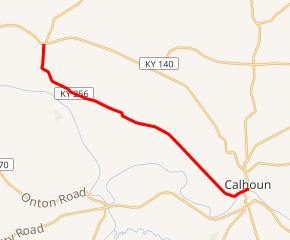
KY 256 begins at an intersection with KY 56 (Main Street) in Beech Grove, within McLean County. It travels to the south-southwest and curves to the southeast. It intersects the northern terminus of KY 1587. Then, it intersects the southern terminus of KY 797. The highway then crosses over Yellow Creek. In Poverty, it intersects the western terminus of KY 140. It curves to the east-southeast and crosses over Long Falls Creek, where it enters Calhoun. It curves to the northeast, travels under a bridge that carries KY 81 (Veterans Memorial Drive). It curves to the north and meets its eastern terminus, an intersection with KY 81 (Veterans Memorial Drive/Main Street).[1]
Major intersections
The entire route is in McLean County.
| Location | mi[1] | km | Destinations | Notes | |
|---|---|---|---|---|---|
| Beech Grove | 0.0 | 0.0 | Western terminus | ||
| | 0.9 | 1.4 | Northern terminus of KY 1587 | ||
| | 2.7 | 4.3 | Southern terminus of KY 797 | ||
| Poverty | 5.9 | 9.5 | Western terminus of KY 140 | ||
| Calhoun | 10.5 | 16.9 | Eastern terminus | ||
| 1.000 mi = 1.609 km; 1.000 km = 0.621 mi | |||||
See also


References
- Google (May 29, 2016). "Kentucky Route 256" (Map). Google Maps. Google. Retrieved May 29, 2016.