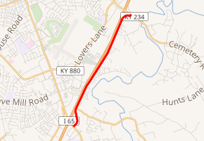
Kentucky Route 2158
Kentucky Route 2158 is a north–south highway in Warren County, Kentucky. It parallels Interstate 65 (I-65) for all of its length. It is known locally as Cumberland Trace.
| ||||
|---|---|---|---|---|

| ||||
| Route information | ||||
| Maintained by KYTC | ||||
| Length | 3.546 mi[1] (5.707 km) | |||
| Major junctions | ||||
| South end | ||||
| North end | ||||
| Location | ||||
| Counties | Warren | |||
| Highway system | ||||
| ||||
Route description
KY 2158 starts at a junction with U.S. Route 231 (US 231), known locally as Scottsville Road. 0.6 miles (0.97 km) north of this intersection, KY 2158 has a junction with KY 2629, a west–east route that begins at this point.
KY 2158 then continues north for another three miles (4.8 km) before reaching its terminus at KY 234, just east of the exit 26 interchange with I-65.
From its beginning until the intersection with KY 2629, KY 2158 is surrounded primarily by commercial development. North of the intersection, the highway is primarily surrounded by residential development.
Major intersections
The entire route is in Bowling Green, Warren County.
| mi[1] | km | Destinations | Notes | ||
|---|---|---|---|---|---|
| 0.000 | 0.000 | ||||
| 0.538 | 0.866 | Western terminus of KY 2629 | |||
| 3.546 | 5.707 | ||||
| 1.000 mi = 1.609 km; 1.000 km = 0.621 mi | |||||
References
- Commonwealth of Kentucky. "Official DMI Route Log". p. 7. Retrieved January 29, 2013.
