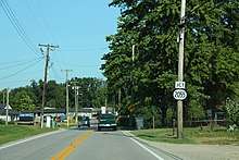
Kentucky Route 2055
Kentucky Route 2055 (KY 2055) is a 4.206-mile-long (6.769 km) state highway in the U.S. State of Kentucky. Its southern terminus is at KY 1020 in Louisville and its northern terminus is at KY 907 in Louisville.
| ||||
|---|---|---|---|---|
| Route information | ||||
| Maintained by KYTC | ||||
| Length | 4.206 mi[1] (6.769 km) | |||
| Major junctions | ||||
| South end | ||||
| ||||
| North end | ||||
| Location | ||||
| Counties | Jefferson | |||
| Highway system | ||||
| ||||
Major junctions
The entire route is in Louisville, Jefferson County.
| mi[1] | km | Destinations | Notes | ||
|---|---|---|---|---|---|
| 0.000 | 0.000 | Southern terminus | |||
| 1.997 | 3.214 | Southern terminus of KY 1865 | |||
| 4.206 | 6.769 | Northern terminus | |||
| 1.000 mi = 1.609 km; 1.000 km = 0.621 mi | |||||
Gallery

KY 1020 approaching KY 2055
gollark: In the A, B and C example, I'd want servers B and C to continue working even if A fails.
gollark: I mean, more generally, if I ensure that the servers are arranged acyclically, it gets easier, but that also has redundancy issues.
gollark: Yes, but I want redundancy.
gollark: I wonder if it would be possible to somehow run skynet routing on top of BGP or something insane like that.
gollark: What network?
References
- Commonwealth of Kentucky. "Official DMI Route Log". Retrieved 19 November 2019.
This article is issued from Wikipedia. The text is licensed under Creative Commons - Attribution - Sharealike. Additional terms may apply for the media files.
