Kentucky Route 1508
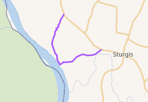
Kentucky Route 1508 (KY 1508) is a state highway located in northwestern Kentucky. The route starts at KY 109, west of Sturgis. It travels westward to unincorporated area of Caseyville, and turns north near the Ohio River. KY 1508 then travels through the community of Dekoven, before ending at KY 109, northwest of its southern terminus. The route was designated around 1967, after the KY 130 designation was removed from the section in Caseyville, which was connected to the community since 1939.
| ||||
|---|---|---|---|---|

Route 1508 highlighted in purple | ||||
| Route information | ||||
| Maintained by KYTC | ||||
| Length | 7.565 mi[1] (12.175 km) | |||
| Existed | c. 1967–present | |||
| Major junctions | ||||
| South end | ||||
| North end | ||||
| Location | ||||
| Counties | Union | |||
| Highway system | ||||
| ||||
Route description

All of the route is located inside Union County.[2] In 2017, the Kentucky Transportation Cabinet (KYTC) calculated as many as 277 vehicles, including 17 trucks traveling on KY 1508 west of Locust Lick Road, and as few as 72 vehicles, including 16 trucks traveling north of Lawyer Loop. This is expressed in terms of annual average daily traffic (AADT), a measure of traffic volume for any average day of the year.[3] KY 1508 is part of the Rural Secondary System of the State Primary Road System.[4]
KY 1508 starts at a three-way junction at KY 109 west of the city of Sturgis and travels southwestwards. The road travels through farmland, and it intersects Tradewater Road, which leads to state maintained KY 923. It then borders the Big Rivers Wildlife Management Area and State Forest,[2] with one entrance at Locust Lick Road.[1][5] The road then crosses over an unnamed stream near Lover's Lane Road.[1] At Caseyville Cemetery Road, the state forest no longer borders the route. KY 1508 reaches the center of the unincorporated area of Caseyville near Hill Street.[2] A source of sand and gravel for KYTC Division of Materials is located off KY 1508 and Bell Tip Road.[1][6] Right after the intersection at Bell Tip Road, an entrance to the Union County Boat Ramp is located to the south side of the road.[1] KY 1508 turns sharply north at Brooks Street,[1][5] and travels toward the unincorporated area of Mulfordtown, parallel to the Ohio River.[2] The road travels through the center of the community, centered north of the western terminus of Caseyville Cemetery Road.[5]
The route enters a small forest and crosses over a few unnamed streams,[5][1] before entering a small stretch of farmland.[5] The road intersects Berry Stevens Road and Lyman Road near Dekoven.[1][2] Past Lyman Road, KY 1508 becomes concurrent with KY 492 as it continues northward, although KY 492 is unsigned past the intersection at KY 1508. The concurrency ends at KY 667 0.097 miles (0.156 km) later, as the southern terminus of KY 492 is located at the intersection.[1] KY 1508 travels northeastward and uphill past houses after intersecting KY 667. The road soon re-emerges into the large tracts of farmland,[5] intersecting Rhem Road south of its terminus. The route ends at KY 109 at a T-intersection soon afterwards.[2]
History
Since 1939, Caseyville was connected to the state highway system by KY 130, which was also concurrent with KY 85 north of the town.[7][8] By 1957, the section of KY 130 from Caseyville to KY 85 was paved in asphalt,[8][9] and KY 85 was renumbered to KY 109 about five years later.[9][10] KY 130 was truncated to KY 109 near Henshaw in 1966,[11][12] and the KY 1508 designation appeared on the state map the year after.[12][13] The route was officially designated on September 26, 1980, as part of Official Order 85592, with an extension northwards to a new terminus at KY 109 near Dekoven.[4]
Major intersections
The entire route is in Union County.
| Location | mi[1] | km | Destinations[2] | Notes | |
|---|---|---|---|---|---|
| | 0.000 | 0.000 | Southern terminus | ||
| | 0.425 | 0.684 | Tradewater Road to | ||
| | 6.285 | 10.115 | 0.097-mile (0.156 km) concurrency with KY 492 | ||
| | |||||
| | 7.565 | 12.175 | Northern terminus | ||
| 1.000 mi = 1.609 km; 1.000 km = 0.621 mi | |||||
References
- Kentucky Transportation Cabinet. "HIS Official Milepoint Route Log Report". Frankfort: Kentucky Transportation Cabinet. Retrieved July 17, 2017.
- Kentucky Transportation Cabinet (2016). Union County, Kentucky (PDF) (Map). c. 1:168,960. Frankfort: Kentucky Transportation Cabinet. Retrieved February 10, 2018.
- Kentucky Transportation Cabinet (2017). "Traffic Counts". Kentucky Transportation Cabinet. Retrieved February 10, 2018.
- Kentucky Transportation Cabinet (December 18, 2015). "Union County State Primary Road System" (PDF). Frankfort: Kentucky Transportation Cabinet. p. 3. Retrieved July 17, 2017.
- Google (February 10, 2018). "Kentucky Route 1508" (Map). Google Maps. Google. Retrieved February 10, 2018.
- Kentucky Transportation Cabinet (January 24, 2018). "Aggregate Source Book" (PDF). Kentucky Transportation Cabinet. p. 2-3. Retrieved February 10, 2018.
- Kentucky State Highway Department (January 1, 1928). Map of Kentucky Showing Condition of State Roads (PDF) (Map). Scale not given. Frankfort: Kentucky State Highway Department. Retrieved February 10, 2018.
- Kentucky Department of State Highways (September 15, 1939). Road Map of Kentucky (PDF) (Map). c. 1:760,320. Frankfort: Kentucky Department of State Highways. Retrieved February 10, 2018.
- Kentucky Department of Highways (1957). Kentucky Official Highway Map (PDF) (Map). c. 1:760,320. Frankfort: Kentucky Department of Highways. Retrieved February 10, 2018.
- Kentucky Department of Highways (1962). Kentucky Official Highway Map (PDF) (Map). c. 1:760,320. Frankfort: Kentucky Department of Highways. Retrieved February 10, 2018.
- Kentucky Department of Highways (1965). Kentucky Official Highway Map (PDF) (Map). c. 1:760,320. Frankfort: Kentucky Department of Highways. Retrieved February 10, 2018.
- Kentucky Department of Highways (1966). Kentucky Official Highway Map (PDF) (Map). c. 1:760,320. Frankfort: Kentucky Department of Highways. Retrieved February 10, 2018.
- Kentucky Department of Highways (1967). Kentucky Official Highway Map (PDF) (Map). c. 1:760,320. Frankfort: Kentucky Department of Highways. Retrieved February 10, 2018.
