Kentucky Route 85
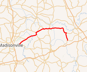
Kentucky Route 85 (KY 85) is a 33.150-mile-long (53.350 km) state highway in Kentucky that runs from Kentucky Route 70 west of Madisonville to U.S. Route 62 northeast of Rockport via Sacramento and Centertown.
| ||||
|---|---|---|---|---|

KY 85 highlighted in red | ||||
| Route information | ||||
| Maintained by KYTC | ||||
| Length | 33.150 mi[1] (53.350 km) | |||
| Major junctions | ||||
| West end | ||||
| East end | ||||
| Location | ||||
| Counties | Hopkins, McLean, Ohio | |||
| Highway system | ||||
| ||||
Major intersections
| County | Location | mi[1] | km | Destinations | Notes |
|---|---|---|---|---|---|
| Hopkins | | 0.000 | 0.000 | Western terminus | |
| | 1.093 | 1.759 | Eastern terminus of KY 2339 | ||
| | 2.722 | 4.381 | Southern terminus of KY 2082 | ||
| | 3.014 | 4.851 | Eastern terminus of KY 862 | ||
| | 4.254 | 6.846 | West end of KY 862 overlap | ||
| | 4.380 | 7.049 | East end of KY 862 overlap | ||
| McLean | | 10.147 | 16.330 | West end of KY 81 overlap | |
| Sacramento | 10.925 | 17.582 | Eastern terminus of KY 254 | ||
| 11.202 | 18.028 | East end of KY 81 overlap | |||
| | 11.656 | 18.759 | Southern terminus of KY 2383 | ||
| | 12.306 | 19.805 | Southern terminus of KY 2109 | ||
| | 15.196 | 24.456 | Eastern terminus of KY 2226 | ||
| | 16.888 | 27.179 | Southern terminus of KY 891 | ||
| | 18.457 | 29.704 | Southern terminus of KY 2110 | ||
| | 18.721 | 30.129 | |||
| | 19.053 | 30.663 | West end of KY 1412 overlap | ||
| | 19.778 | 31.830 | East end of KY 1412 overlap | ||
| Ohio | | 28.222 | 45.419 | West end of KY 69 overlap | |
| | 29.059 | 46.766 | East end of KY 69 overlap | ||
| | 30.526 | 49.127 | Northern terminus of KY 1903 | ||
| | 33.150 | 53.350 | Eastern terminus | ||
1.000 mi = 1.609 km; 1.000 km = 0.621 mi
| |||||
Hopkins County + KY 81 Overlap + McLean County = 21.858
gollark: We're shutting it down in 22 seconds.
gollark: This is just a simulation where GTech™ tests what happens if it *is* allowed.
gollark: Nope. It's physically impossible.
gollark: Shades are a human abstraction. Colors are the true apiary.
gollark: Enough for WHAT?!?!?!?!?!???!?!?!?!?
References
- Commonwealth of Kentucky. "Official DMI Route Log". Retrieved 27 June 2018.
This article is issued from Wikipedia. The text is licensed under Creative Commons - Attribution - Sharealike. Additional terms may apply for the media files.
